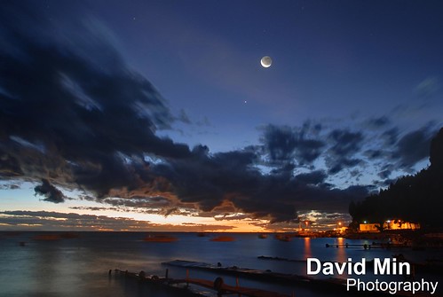
Copacabana is the main Bolivian town on the shore of Lake Titicaca. The town is a destination for tourism in Bolivia. The town is also known for its famous Basilica, home of the Virgin of Copacabana, its trout, and its quaint atmosphere. Built between Mount Calvario and Mount Niño Calvario, the town has approximately 6,000 inhabitants. Copacabana's religious celebrations, cultural patrimony, and traditional festivals are well known throughout Bolivia. Boats leave for Isla del Sol, the sacred Inca island from Copacabana.
Monday, November 26, 2012
Sunday, November 25, 2012
Machu Picchu, Peru - The Andes Range

Sunrise over the Andes range. Photo taken from Machu Picchu.
The Andes is the longest continental mountain range in the world. It is a continual range of highlands along the western coast of South America. This range is about 7,000 km long, about 200 km to 700 km wide, and of an average height of about 4,000 m. The Andes extend from north to south through seven South American countries: Venezuela, Colombia, Ecuador, Peru, Bolivia, Chile and Argentina.
Along its length, the Andes is split into several ranges, which are separated by intermediate depressions. The Andes is the location of several high plateaux – some of which host major cities such as Quito, Bogotá, Arequipa, Medellín, Sucre, and La Paz. The so-called Altiplano plateau is the world's second-highest plateau following the Tibetan plateau.
The Andes range is the world's highest mountain range outside of Asia. The highest peak, Mount Aconcagua, rises to an elevation of about 6,962 m above sea level.
Thursday, November 22, 2012
Zanzibar, Tanzania - Tropical Paradise
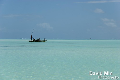
The village of Jambiani is situated on the southeast coast of Zanzibar Island, some 45 km from main city Stone Town. It is an approximately 4 kilometers long and narrow settlement of originally 13 smaller separated villages, today grown together to one, but each still carrying their original name. Jambiani Beach is miles of startling white sand.
The legend tells that the first people to settle here found a dagger (in Arabic: 'jambya') in the sand, and then called their settlement 'Jambiani'.
The village houses some 6000 inhabitants whose everyday lives are closely connected to the tidal cycle of the Indian Ocean, which determines the pattern of activities in the village and on the beach. A common feature is to see the women attending to their seaweed farms on low tide, and the fishermen returning their dhows from the reef with the fresh catch of octopus and other species on high tide.
The unique and seductive charm of Jambiani is evident and the villagers are most friendly to their visitors. It is definitely not hard to feel at home here. A short walk through the village is good proof of this as almost anyone, young and old, greets you Karibu/Welcome, where ever you go. Even the household of ducks, hens, goats and cows moving around in the village are greeting you in their own friendly way…
Jambiani was, until recently, not too easy to access. The last 5-6 km on a bumpy dirt road from Paje, took as long time to pass by car as the first 40 km from Stone Town. But today that is ancient history as a new paved road has been completed during 2007.
Jambiani now has its own health clinic and hospital, several schools, internet places, post office and many other smaller shops where it is possible to get most of what you need – but if you are looking for special shopping possibilities, a trip to Stone Town is inevitable. Then a ride with the local bus, the dala dala, brings you close to the locals – and an unforgettable experience is guaranteed!
Saturday, November 17, 2012
Chamonix, France - Ice Climbing
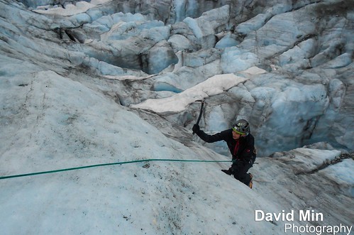
I discovered Ice Climbing and it's an awesome activity !!!
Ice climbing, as the term indicates, is the activity of ascending inclined ice formations. Usually, ice climbing refers to roped and protected climbing of features such as icefalls, frozen waterfalls, and cliffs and rock slabs covered with ice refrozen from flows of water.
Argentière is a picturesque skiing, alpine walking and mountaineering village in the French Alps, part of the commune of Chamonix Mont Blanc.
Argentière is located near the head of the valley of Chamonix approximately 7 km from Chamonix town. It is connected by road with Switzerland by the pass over the Col des Montets, and the Col de la Forclaz to Martigny in the Rhône valley. The village also lies on the route of the incredibly scenic Mont Blanc Express railroad which runs from St Gervais / Le Fayet through Chamonix, Argentiere and Vallorcine before crossing the Franco/Swiss border at Chatelard, passing through Finhaut before reaching the 'end of the line' in Martigny.
The Argentière glacier lies to the south-east of the village, and is bound on its north-east side by the Aiguille du Chardonnet, the Aiguille d'Argentière and the Tour Noir, and on its south-west by the Aiguille Verte, Les Droites and Les Courtes.
My video of Mont Blanc climbing is here : youtu.be/3xAeVLIcFKw
Sunday, November 4, 2012
Chamonix, France - Sunrise (6.30 am) & Windy Day @Mont Maudit (4 465m)

Chamonix, France - Sunrise (6.30 am) & Windy Day @Mont Maudit (4 465m), a photo by GlobeTrotter 2000 on Flickr.
This photo was taken on 12nd July 2012, day of the tragedy when 9 alpinists were killed by an avalanche on Mont-Blanc.
Sometimes the Mont Maudit is debased to be only a satellite of the Mont Blanc instead of an independent goal of climbers. But this judgement is not justified at all since the Mont Maudit has a lot of very interesting and difficult couloirs. It is an important climbing mountain of the Mont Blanc MASSIF. The ice-balconies of the Mont Maudit are only one part. It is the "tame" side with direction to the West and Northwest. You traverse these glacier flanks if you climb the Mont Blanc via the Mont Blanc du Tacul starting from the Aiguille du Midi. As part of this Mont Blanc route, the Mont Maudit (which lies in the Northeast of the Mont Blanc, 1,8 km far away from the main summit of the Mont Blanc) is interesting for "normal" alpinists who usually climb 4000m peaks. On this way, it takes already 6 to 7 hours from the Aiguille du Midi via the Mont Blanc du Tacul.
Saturday, November 3, 2012
Kilimanjaro, Tanzania - Tribute to the Kilimanjaro Porters
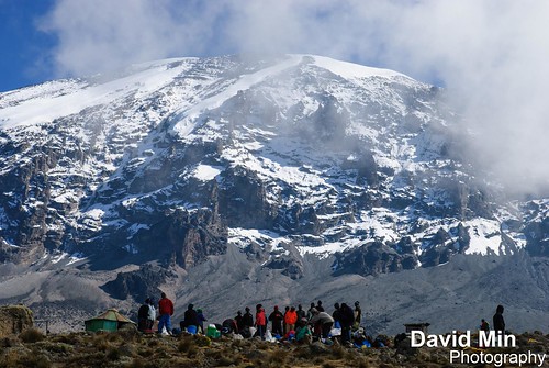
Porters on Kilimanjaro today will earn on average Ts24,000- 36,000 (around US$20-30) for a six-day trip - plus the undying gratitude of anyone who’s ever trekked with them.These men (and the ones hired by trekkers are nearly always male) never fail to draw admiration from the trekkers who hire them. Ranging in age from about 18 (the minimum legal age, though some look a good deal younger) to 40 (though occasionally way beyond this), porters are amongst the hardest workers on Kilimanjaro. To see them traipsing up the mountain, water in one hand, cooker in another, rucksack on the back and picnic table on the head, is staggering to behold. And though they are supposed to carry no more than 15kg, many, desperate for work in what is an over-supplied market, carry much, much more.
And if that isn’t enough, while at the end of the day the average trekker spends his or her time at camp moaning about the hardships they are suffering – in between cramming down mouthfuls of popcorn while clasping a steaming hot cup of tea – these hardy individuals are putting up the tents, helping with the preparation of the food, fetching more water and generally making sure every trekker’s whim is, within reason, catered for.
Yet in spite of appearances to the contrary, porters are not indestructible. Though they rarely climb to the summit themselves, a few still expire each year on the slopes of Kilimanjaro. The most common cause of death, perhaps unsurprisingly given the ragged clothes many wear, is exposure. For this reason, if you see a porter dozing on the wayside and it’s getting a bit late, put aside your concerns about depriving him of some much needed shut-eye and wake him up: many are the tales of porters who have perished on Kilimanjaro because they took forty winks and then couldn’t find their way back to camp in the dark.
It’s this kind of horror story that has caused so much concern over recent years and led to the formation of organizations such as the Kilimanjaro Porters Assistance Project.
Thursday, November 1, 2012
Chamonix, Mont-Blanc - Aiguille du Midi
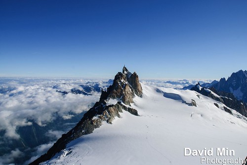
The Aiguille du Midi (3,842 m) is a mountain in the Mont Blanc massif in the French Alps.
The cable car to the summit, the Téléphérique de l'Aiguille du Midi, was built in 1955 and held the title of the world's highest cable car for about two decades. It still holds the record as the highest vertical ascent cable car in the world, from 1,035 m to 3,842 m. There are two sections: from Chamonix to Plan de l'Aiguille at 2,317 m and then directly, without any support pillar, to the upper station at 3,777 m (the building contains an elevator to the summit). The span of the second section is 2,867 m measured directly, but only 2,500 m measured horizontally. Thus it remains the second longest span width, measured directly. The tramway travels from Chamonix to the top of the Aiguille du Midi – an altitude gain of over 2,800 m – in 20 minutes. An adult ticket from Chamonix (as of 9/5/2012 to 30/11/2012) is €52.20 return.
The Aiguille summit contains a panoramic viewing platform, a cafe and a gift shop. The Vallée Blanche ski run begins here, and the nearby Cosmiques Refuge is the starting point for one of the routes to the Mont Blanc summit. From the Aiguille another cable car (summer months only), the Vallee Blanche Aerial Tramway crosses the Glacier du Geant to Pointe Helbronner (3,462 m) at the Italian side of the Mont Blanc Massif. Pointe Helbronner is served with a cable car from La Palud, a village near Courmayeur in the Aosta Valley (Italy).
My video of Mont Blanc climbing is here : youtu.be/3xAeVLIcFKw
Subscribe to:
Posts (Atom)