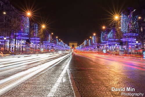
Every year, for Christmas and the New Year, the avenue des Champs-Elysées is decorated with lights and stunning decorations. Star bursts, sparkling garlands, rings of light, shimmering curtain effect … bring the 200 trees along the world’s most beautiful avenue to life … A festive landscape for a magical Christmas!
Don't forget to visit the Christmas market in the area while you're at it, to grab some mulled wine and find some original Parisian Christmas gifts.
Sunday, December 23, 2012
Paris, France - Merry Christmas @Champs-Elysées
Saturday, December 15, 2012
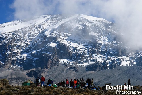
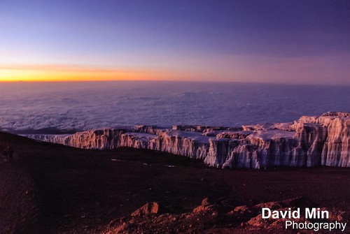
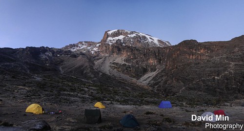
Sunset @Mount Kilimanjaro, Tanzania
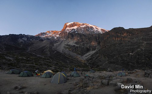
Kilimanjaro, with its three volcanic cones, Kibo, Mawenzi, and Shira, is a dormant volcano in Kilimanjaro National Park, Tanzania and the highest mountain in Africa at 5,895 metres above sea level (the Uhuru Peak/Kibo Peak).
There are six official trekking routes by which to climb Mt Kilimanjaro, namely: Marangu, Rongai, Lemosho, Shira, Umbwe and Machame. Of all the routes, Machame is by far the most scenic albeit steeper route up the mountain, which can be done in six or seven days. The Rongai is the easiest and least scenic of all camping routes with the most difficult summit night and the Marangu is also relatively easy, but accommodation is in shared huts with all other climbers. As a result, this route tends to be very busy, and ascent and descent routes are the same.
People who wish to trek to the summit of Kilimanjaro are advised to undertake appropriate research and ensure that they are both properly equipped and physically capable. Though the climb is technically not as challenging as when climbing the high peaks of the Himalayas or Andes, the high elevation, low temperature, and occasional high winds make this a difficult and dangerous trek. Acclimatisation is essential, and even then most experienced trekkers suffer some degree of altitude sickness.
Tuesday, December 11, 2012
Sunday, December 9, 2012
Pokhara, Nepal - Annapurna Sanctuary

The Annapurna Sanctuary is high glacial basin lying forty kilometers directly north of Pokhara. This oval-shaped plateau sits at an altitude of over 4000 meters, and is surrounded by a ring of mountains, the Annapurna range, most of which are over 7000 meters. With the only entrance a narrow pass between the peaks of Hiunchuli and Machapuchare, where run-off from glaciers drain into Modi Khola River, the Sanctuary was not penetrated by outsiders until 1956. Because of high mountains on all sides, the Annapurna Sanctuary receives only 7 hours of sunlight a day at the height of summer. The unique combination of heights and depths in the Annapurna Sanctuary give rise to an extraordinary variety of ecosystems. The south-facing slope are “covered in dense tropical jungles of rhododendron and bamboo”, while the north-facing slopes, in the rain shadow, have “a drier colder climate similar to that of the near-by Tibetan Plateau.”
The entire sanctuary was held as sacred to the Gurung people, one of the many native people to inhabit the area. They believed it was the repository of gold and various treasures left by the Nāgas, the serpent-gods known in India. The sanctuary was believed to be the home of several deities, from Hinduism and Buddhism as well the older animistic gods. The peak of Machapuchare at the entrance was believed to be the home of the god Shiva, and the daily plumes of snow were thought the smoke of his divine incense. Until recently, the local Gurang people forbade anyone from bringing eggs or meat into the Annapurna Sanctuary, and women and untouchables were prohibited from going there as well.
In recent years, the number of trekkers to the Sanctuary has increased substantially, in part because the Sanctuary forms the base of one of the major routes to the peaks of the Annapurna range. The Annapurna Sanctuary is now part of the Annapurna Conservation Area Project, which places restrictions on number of outside travelers, gathering of firewood, and domestic animal grazing.
Wednesday, December 5, 2012
Ngorongoro Crater, Tanzania
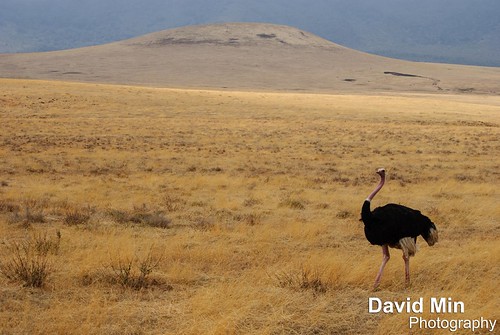
The Ngorongoro Conservation Area is a conservation area and a UNESCO World Heritage Site situated 180 km west of Arusha in the Crater Highlands area of Tanzania. The Ngorongoro Crater, a large volcanic caldera, lies within the area.
A population of approximately 25,000 large animals, largely ungulates along with reputedly the highest density of mammalian predators in Africa, lives in the crater. Large animals in the crater include the black rhinoceros, the local population of which declined from about 108 in 1964-66 to between 11-14 in 1995, and the hippopotamus, which is very uncommon in the area. There also are many other ungulates: the wildebeest (7,000 estimated in 1994), the zebra (4,000), the eland, and Grant's and Thompson's gazelles (3,000).
The crater has the densest known population of lions, numbering 62 in 2001. On the crater rim are leopards, elephants – numbering 42 in 1987 but only 29 in 1992 – mountain reedbuck, and buffalo (4,000 in 1994). In the middle of the crater there is a large lake inhabited by hundreds of flamingoes and from a distance, they appear as a pink border of the lake.
Aside from herds of zebra, gazelle, and wildebeest, the crater is home to the "big five" of rhinoceros, lion, leopard, elephant, and buffalo. The crater plays host to almost every individual species of wildlife in East Africa, with an estimated 25 000 animals within the crater.
Sunday, December 2, 2012
Annapurna, Nepal - Mount Machapuchare

Machapuchare or Machhapuchhre (6 997m) meaning "Fish Tail" in English, is a mountain in the Annapurna Himalaya of north central Nepal. It is revered by the local population as particularly sacred to the god Shiva, and hence is off limits to climbing.
Machhapuchhre is at the end of a long spur ridge, coming south out of the main backbone of the Annapurna Himal, that forms the eastern boundary of the Annapurna Sanctuary. The Sanctuary is a favorite trekking destination, and the site of the base camps for the South Face of Annapurna and for numerous smaller objectives.
Due to its southern position in the range, and the particularly low terrain that lies south of the Annapurna Himal, Machapuchare commands tremendous vertical relief in a short horizontal distance. This, combined with its steep, pointed profile, make it a particularly striking peak, despite a lower elevation than some of its neighbors. Its double summit resembles the tail of a fish, hence the name meaning "Fish's Tail" in Nepali language It is also nicknamed the "Matterhorn of Nepal".
Machapuchare has never been climbed to its summit. The only attempt was in 1957 by a British team led by Jimmy Roberts. Climbers Wilfrid Noyce and A. D. M. Cox climbed to within 50 m of the summit via the north ridge, but did not complete the ascent; they had promised not to set foot on the actual summit. Since then, the mountain has been declared sacred, and it is now forbidden to climbers.
Monday, November 26, 2012
Copacabana, Bolivia
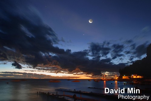
Copacabana is the main Bolivian town on the shore of Lake Titicaca. The town is a destination for tourism in Bolivia. The town is also known for its famous Basilica, home of the Virgin of Copacabana, its trout, and its quaint atmosphere. Built between Mount Calvario and Mount Niño Calvario, the town has approximately 6,000 inhabitants. Copacabana's religious celebrations, cultural patrimony, and traditional festivals are well known throughout Bolivia. Boats leave for Isla del Sol, the sacred Inca island from Copacabana.
Sunday, November 25, 2012
Machu Picchu, Peru - The Andes Range

Sunrise over the Andes range. Photo taken from Machu Picchu.
The Andes is the longest continental mountain range in the world. It is a continual range of highlands along the western coast of South America. This range is about 7,000 km long, about 200 km to 700 km wide, and of an average height of about 4,000 m. The Andes extend from north to south through seven South American countries: Venezuela, Colombia, Ecuador, Peru, Bolivia, Chile and Argentina.
Along its length, the Andes is split into several ranges, which are separated by intermediate depressions. The Andes is the location of several high plateaux – some of which host major cities such as Quito, Bogotá, Arequipa, Medellín, Sucre, and La Paz. The so-called Altiplano plateau is the world's second-highest plateau following the Tibetan plateau.
The Andes range is the world's highest mountain range outside of Asia. The highest peak, Mount Aconcagua, rises to an elevation of about 6,962 m above sea level.
Thursday, November 22, 2012
Zanzibar, Tanzania - Tropical Paradise
The village of Jambiani is situated on the southeast coast of Zanzibar Island, some 45 km from main city Stone Town. It is an approximately 4 kilometers long and narrow settlement of originally 13 smaller separated villages, today grown together to one, but each still carrying their original name. Jambiani Beach is miles of startling white sand.
The legend tells that the first people to settle here found a dagger (in Arabic: 'jambya') in the sand, and then called their settlement 'Jambiani'.
The village houses some 6000 inhabitants whose everyday lives are closely connected to the tidal cycle of the Indian Ocean, which determines the pattern of activities in the village and on the beach. A common feature is to see the women attending to their seaweed farms on low tide, and the fishermen returning their dhows from the reef with the fresh catch of octopus and other species on high tide.
The unique and seductive charm of Jambiani is evident and the villagers are most friendly to their visitors. It is definitely not hard to feel at home here. A short walk through the village is good proof of this as almost anyone, young and old, greets you Karibu/Welcome, where ever you go. Even the household of ducks, hens, goats and cows moving around in the village are greeting you in their own friendly way…
Jambiani was, until recently, not too easy to access. The last 5-6 km on a bumpy dirt road from Paje, took as long time to pass by car as the first 40 km from Stone Town. But today that is ancient history as a new paved road has been completed during 2007.
Jambiani now has its own health clinic and hospital, several schools, internet places, post office and many other smaller shops where it is possible to get most of what you need – but if you are looking for special shopping possibilities, a trip to Stone Town is inevitable. Then a ride with the local bus, the dala dala, brings you close to the locals – and an unforgettable experience is guaranteed!
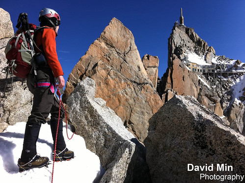
Saturday, November 17, 2012
Chamonix, France - Ice Climbing
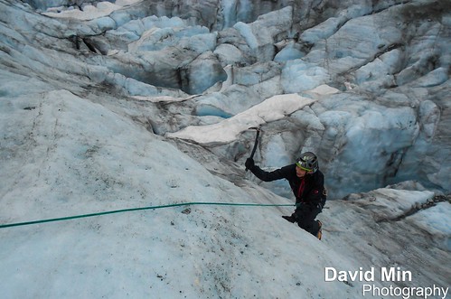
I discovered Ice Climbing and it's an awesome activity !!!
Ice climbing, as the term indicates, is the activity of ascending inclined ice formations. Usually, ice climbing refers to roped and protected climbing of features such as icefalls, frozen waterfalls, and cliffs and rock slabs covered with ice refrozen from flows of water.
Argentière is a picturesque skiing, alpine walking and mountaineering village in the French Alps, part of the commune of Chamonix Mont Blanc.
Argentière is located near the head of the valley of Chamonix approximately 7 km from Chamonix town. It is connected by road with Switzerland by the pass over the Col des Montets, and the Col de la Forclaz to Martigny in the Rhône valley. The village also lies on the route of the incredibly scenic Mont Blanc Express railroad which runs from St Gervais / Le Fayet through Chamonix, Argentiere and Vallorcine before crossing the Franco/Swiss border at Chatelard, passing through Finhaut before reaching the 'end of the line' in Martigny.
The Argentière glacier lies to the south-east of the village, and is bound on its north-east side by the Aiguille du Chardonnet, the Aiguille d'Argentière and the Tour Noir, and on its south-west by the Aiguille Verte, Les Droites and Les Courtes.
My video of Mont Blanc climbing is here : youtu.be/3xAeVLIcFKw
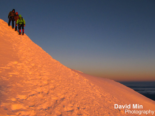
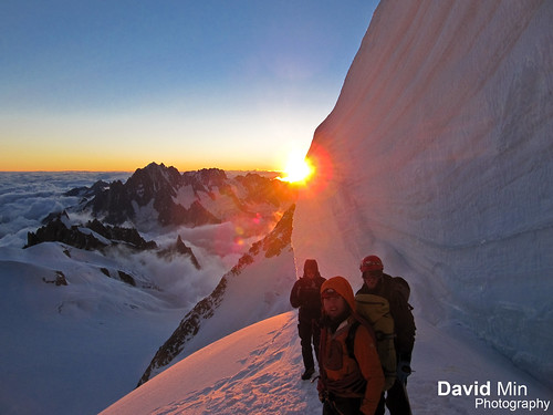
Sunday, November 4, 2012
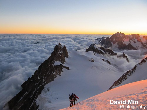
Chamonix, France - Sunrise (6.30 am) & Windy Day @Mont Maudit (4 465m)

Chamonix, France - Sunrise (6.30 am) & Windy Day @Mont Maudit (4 465m), a photo by GlobeTrotter 2000 on Flickr.
This photo was taken on 12nd July 2012, day of the tragedy when 9 alpinists were killed by an avalanche on Mont-Blanc.
Sometimes the Mont Maudit is debased to be only a satellite of the Mont Blanc instead of an independent goal of climbers. But this judgement is not justified at all since the Mont Maudit has a lot of very interesting and difficult couloirs. It is an important climbing mountain of the Mont Blanc MASSIF. The ice-balconies of the Mont Maudit are only one part. It is the "tame" side with direction to the West and Northwest. You traverse these glacier flanks if you climb the Mont Blanc via the Mont Blanc du Tacul starting from the Aiguille du Midi. As part of this Mont Blanc route, the Mont Maudit (which lies in the Northeast of the Mont Blanc, 1,8 km far away from the main summit of the Mont Blanc) is interesting for "normal" alpinists who usually climb 4000m peaks. On this way, it takes already 6 to 7 hours from the Aiguille du Midi via the Mont Blanc du Tacul.
Saturday, November 3, 2012
Kilimanjaro, Tanzania - Tribute to the Kilimanjaro Porters
Porters on Kilimanjaro today will earn on average Ts24,000- 36,000 (around US$20-30) for a six-day trip - plus the undying gratitude of anyone who’s ever trekked with them.These men (and the ones hired by trekkers are nearly always male) never fail to draw admiration from the trekkers who hire them. Ranging in age from about 18 (the minimum legal age, though some look a good deal younger) to 40 (though occasionally way beyond this), porters are amongst the hardest workers on Kilimanjaro. To see them traipsing up the mountain, water in one hand, cooker in another, rucksack on the back and picnic table on the head, is staggering to behold. And though they are supposed to carry no more than 15kg, many, desperate for work in what is an over-supplied market, carry much, much more.
And if that isn’t enough, while at the end of the day the average trekker spends his or her time at camp moaning about the hardships they are suffering – in between cramming down mouthfuls of popcorn while clasping a steaming hot cup of tea – these hardy individuals are putting up the tents, helping with the preparation of the food, fetching more water and generally making sure every trekker’s whim is, within reason, catered for.
Yet in spite of appearances to the contrary, porters are not indestructible. Though they rarely climb to the summit themselves, a few still expire each year on the slopes of Kilimanjaro. The most common cause of death, perhaps unsurprisingly given the ragged clothes many wear, is exposure. For this reason, if you see a porter dozing on the wayside and it’s getting a bit late, put aside your concerns about depriving him of some much needed shut-eye and wake him up: many are the tales of porters who have perished on Kilimanjaro because they took forty winks and then couldn’t find their way back to camp in the dark.
It’s this kind of horror story that has caused so much concern over recent years and led to the formation of organizations such as the Kilimanjaro Porters Assistance Project.
Thursday, November 1, 2012
Chamonix, Mont-Blanc - Aiguille du Midi
The Aiguille du Midi (3,842 m) is a mountain in the Mont Blanc massif in the French Alps.
The cable car to the summit, the Téléphérique de l'Aiguille du Midi, was built in 1955 and held the title of the world's highest cable car for about two decades. It still holds the record as the highest vertical ascent cable car in the world, from 1,035 m to 3,842 m. There are two sections: from Chamonix to Plan de l'Aiguille at 2,317 m and then directly, without any support pillar, to the upper station at 3,777 m (the building contains an elevator to the summit). The span of the second section is 2,867 m measured directly, but only 2,500 m measured horizontally. Thus it remains the second longest span width, measured directly. The tramway travels from Chamonix to the top of the Aiguille du Midi – an altitude gain of over 2,800 m – in 20 minutes. An adult ticket from Chamonix (as of 9/5/2012 to 30/11/2012) is €52.20 return.
The Aiguille summit contains a panoramic viewing platform, a cafe and a gift shop. The Vallée Blanche ski run begins here, and the nearby Cosmiques Refuge is the starting point for one of the routes to the Mont Blanc summit. From the Aiguille another cable car (summer months only), the Vallee Blanche Aerial Tramway crosses the Glacier du Geant to Pointe Helbronner (3,462 m) at the Italian side of the Mont Blanc Massif. Pointe Helbronner is served with a cable car from La Palud, a village near Courmayeur in the Aosta Valley (Italy).
My video of Mont Blanc climbing is here : youtu.be/3xAeVLIcFKw
Monday, October 29, 2012
Ngorongoro Crater, Tanzania

The Ngorongoro Conservation Area is a conservation area and a UNESCO World Heritage Site situated 180 km west of Arusha in the Crater Highlands area of Tanzania. The Ngorongoro Crater, a large volcanic caldera, lies within the area.
A population of approximately 25,000 large animals, largely ungulates along with reputedly the highest density of mammalian predators in Africa, lives in the crater. Large animals in the crater include the black rhinoceros, the local population of which declined from about 108 in 1964-66 to between 11-14 in 1995, and the hippopotamus, which is very uncommon in the area. There also are many other ungulates: the wildebeest (7,000 estimated in 1994), the zebra (4,000), the eland, and Grant's and Thompson's gazelles (3,000).
The crater has the densest known population of lions, numbering 62 in 2001. On the crater rim are leopards, elephants – numbering 42 in 1987 but only 29 in 1992 – mountain reedbuck, and buffalo (4,000 in 1994). In the middle of the crater there is a large lake inhabited by hundreds of flamingoes and from a distance, they appear as a pink border of the lake.
Aside from herds of zebra, gazelle, and wildebeest, the crater is home to the "big five" of rhinoceros, lion, leopard, elephant, and buffalo. The crater plays host to almost every individual species of wildlife in East Africa, with an estimated 25 000 animals within the crater.
Tuesday, October 9, 2012
Kilimanjaro Summit, Tanzania - Above the clouds 5.50am @Uhuru Peak (5 895m)
Kilimanjaro Summit, Tanzania - Above the clouds 5.50am @Uhuru Peak (5 895m), a photo by GlobeTrotter 2000 on Flickr.
The trek to Uhuru Peak is considered to be a relatively straightforward endeavour; however, ample time must still be provided for proper acclimatization to prevent altitude sickness. The three shortest routes, Marangu, Rongai and Machame are less challenging and are often trekked by individuals with limited mountaineering experience. Taking at least 7 days is the best way to avoid altitude sickness.
Route travel times range from 5 to 9 days to summit and return to the base of the mountain. Huts with cooking facilities, bathrooms, and electricity are available on the Marangu route, and camps with less facilities are available on many other routes. All huts and many camps have rangers stationed at them with rescue facilities (modified wheelbarrows to transport trekkers stricken with altitude sickness to lower altitudes).
Summit attempts are generally undertaken at night so that trekkers can reach the rim of the crater to view the sunrise so typically clients start walking around midnight. walking overnight also means the ground (loose gravel) is frozen, making the going significantly easier.
Friday, October 5, 2012
Stown Town, Zanzibar - Old City
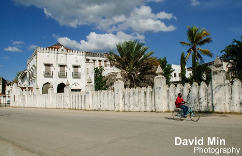
Stone Town is the main city on Zanzibar. It is a city of prominent historical and artistic importance in East Africa. Its architecture, mostly dating back to the 19th century, reflects the diverse influences underlying the Swahili culture, with a unique mixture of Moorish, Arab, Persian, Indian and European elements. For this reason, the town has been included in UNESCO's World Heritage Sites in 2000.
It may not have a particularly romantic name, but Stone Town is the old city and cultural heart of Zanzibar, little changed in the last 200 years. It is a place of winding alleys, bustling bazaars, mosques and grand Arab houses whose original owners vied with each other over the extravagance of their dwellings. This one-upmanship is particularly reflected in the brass-studded, carved, wooden doors - there are more than 500 different examples of this handiwork. You can spend many idle hours and days just wondering through the fascinating labyrinth of narrow streets and alleyways.
Wednesday, October 3, 2012
Kilimanjaro, Tanzania - Karanga High Camp
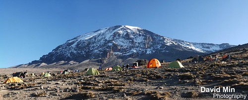
There are several routes by which to reach Kibo, or Uhuru Peak, the highest summit of Mount Kilimanjaro, namely, Marangu, Rongai, Lemosho, Shira, Umbwe and Machame.
Annually, approximately 15,000 people attempt to reach the summit of the mountain, of whom 40% do so.
Of all the routes, Machame is by far the most scenic albeit steeper route up the mountain. The Rongai is the easiest camping route and the Marangu is also easy, but accommodation is in huts. As a result, this route tends to be very busy and ascent and descent routes are the same. Although the Rongai route is a flatter walk it offers less opportunities for acclimatisation. The Machame and Lemosho routes both allow better opportunities to "walk high and sleep low" which is critical to avoiding altitude sickness.
The fourth day of trekking starts with the ascent of the Barranco Wall, which is considered a scramble in climbing terms. The top of the Wall has attractive vistas of Kibo and the surrounding landscape. The trail continues with many up and down sections across small streams and rivulets, and finally crosses the Karanga River to the Karanga campsite.
Sunday, September 30, 2012
Mount Kilimanjaro, Tanzania
Kilimanjaro, with its three volcanic cones, Kibo, Mawenzi, and Shira, is a dormant volcano in Kilimanjaro National Park, Tanzania and the highest mountain in Africa at 5,895 metres above sea level (the Uhuru Peak/Kibo Peak).
There are six official trekking routes by which to climb Mt Kilimanjaro, namely: Marangu, Rongai, Lemosho, Shira, Umbwe and Machame. Of all the routes, Machame is by far the most scenic albeit steeper route up the mountain, which can be done in six or seven days. The Rongai is the easiest and least scenic of all camping routes with the most difficult summit night and the Marangu is also relatively easy, but accommodation is in shared huts with all other climbers. As a result, this route tends to be very busy, and ascent and descent routes are the same.
People who wish to trek to the summit of Kilimanjaro are advised to undertake appropriate research and ensure that they are both properly equipped and physically capable. Though the climb is technically not as challenging as when climbing the high peaks of the Himalayas or Andes, the high elevation, low temperature, and occasional high winds make this a difficult and dangerous trek. Acclimatisation is essential, and even then most experienced trekkers suffer some degree of altitude sickness.
Tuesday, September 25, 2012
Ngorongoro Crater, Tanzania

The Ngorongoro Conservation Area is a conservation area and a UNESCO World Heritage Site situated 180 km west of Arusha in the Crater Highlands area of Tanzania. The Ngorongoro Crater, a large volcanic caldera, lies within the area.
A population of approximately 25,000 large animals, largely ungulates along with reputedly the highest density of mammalian predators in Africa, lives in the crater. Large animals in the crater include the black rhinoceros, the local population of which declined from about 108 in 1964-66 to between 11-14 in 1995, and the hippopotamus, which is very uncommon in the area. There also are many other ungulates: the wildebeest (7,000 estimated in 1994), the zebra (4,000), the eland, and Grant's and Thompson's gazelles (3,000).
The crater has the densest known population of lions, numbering 62 in 2001. On the crater rim are leopards, elephants – numbering 42 in 1987 but only 29 in 1992 – mountain reedbuck, and buffalo (4,000 in 1994). In the middle of the crater there is a large lake inhabited by hundreds of flamingoes and from a distance, they appear as a pink border of the lake.
Aside from herds of zebra, gazelle, and wildebeest, the crater is home to the "big five" of rhinoceros, lion, leopard, elephant, and buffalo. The crater plays host to almost every individual species of wildlife in East Africa, with an estimated 25 000 animals within the crater.
Sunday, September 2, 2012
NYC - Fast & Furious Yellow Cabs

The taxicabs of New York City, with their distinctive yellow paint, are a widely recognized icon of the city. Taxicabs are operated by private companies and licensed by the New York City Taxi and Limousine Commission. The Commission is a New York City government agency that is best known for its responsibility for the more than 13,237 taxis operating in the city. It also oversees over 40,000 other for-hire vehicles, including "black cars", commuter vans and ambulettes. "Medallion taxis," the familiar yellow cabs, are the only vehicles in the city permitted to pick up passengers in response to a street hail.
Friday, August 31, 2012
Chamonix, Mont-Blanc - Above the Clouds
Getty | Facebook Fan Page | Twitter | Google + | Blogger | Tumblr | Formspring
Chamonix is dominated by the white majestic dome of Mont Blanc, at 4,810m the highest mountain in western Europe.
Every year the summit of Mont Blanc becomes the ultimate objective for mountaineers the world over, all striving to stand on top of the roof of Europe and look down on all of the major summits of the Alps.
To climb Mont Blanc from Chamonix, people normally chose one of the two most common routes. Slightly more technical, the route from the Aiguille du Midi, over Mont Blanc du Tacul and Mont Maudit is generally quieter, and highly dependent on conditions.
The slightly easier and more reliable option is via the Tramway du Mont Blanc to the Nid d'Aigle, then up the Aiguille du Gouter and the Bosse ridge.
While not technically challenging, ascending Mont Blanc requires a high level of physical fitness and experience using crampons and an ice axe.
The video of Mont Blanc climbing is here : youtu.be/3xAeVLIcFKw
Thursday, August 23, 2012
Chamonix, Mont-Blanc - Freedom

The Aiguille du Midi (3,842 m) is a mountain in the Mont Blanc massif in the French Alps.
The cable car to the summit, the Téléphérique de l'Aiguille du Midi, was built in 1955 and held the title of the world's highest cable car for about two decades. It still holds the record as the highest vertical ascent cable car in the world, from 1,035 m to 3,842 m. There are two sections: from Chamonix to Plan de l'Aiguille at 2,317 m and then directly, without any support pillar, to the upper station at 3,777 m (the building contains an elevator to the summit). The span of the second section is 2,867 m measured directly, but only 2,500 m measured horizontally. Thus it remains the second longest span width, measured directly. The tramway travels from Chamonix to the top of the Aiguille du Midi – an altitude gain of over 2,800 m – in 20 minutes. An adult ticket from Chamonix (as of 9/5/2012 to 30/11/2012) is €52.20 return.
The Aiguille summit contains a panoramic viewing platform, a cafe and a gift shop. The Vallée Blanche ski run begins here, and the nearby Cosmiques Refuge is the starting point for one of the routes to the Mont Blanc summit. From the Aiguille another cable car (summer months only), the Vallee Blanche Aerial Tramway crosses the Glacier du Geant to Pointe Helbronner (3,462 m) at the Italian side of the Mont Blanc Massif. Pointe Helbronner is served with a cable car from La Palud, a village near Courmayeur in the Aosta Valley (Italy).
The video of Mont Blanc climbing is here : youtu.be/3xAeVLIcFKw
Wednesday, August 15, 2012
Chamonix, France - Mont Maudit (4 465m) - Remember ...
This photo was taken on 12nd July 2012, day of the tragedy when 9 alpinists were killed by an avalanche on Mont-Blanc.
You can see the avalanche on this shot (note) that reminds us we are nothing versus the nature !
Thanks to our guide Matthieu who had the brilliant idea to delay of 1 hour our departure that day. Definitively, his decision allowed us to avoid the avalanche and save our lives !!!
Sometimes the Mont Maudit is debased to be only a satellite of the Mont Blanc instead of an independent goal of climbers. But this judgement is not justified at all since the Mont Maudit has a lot of very interesting and difficult couloirs. It is an important climbing mountain of the Mont Blanc MASSIF. The ice-balconies of the Mont Maudit are only one part. It is the "tame" side with direction to the West and Northwest. You traverse these glacier flanks if you climb the Mont Blanc via the Mont Blanc du Tacul starting from the Aiguille du Midi. As part of this Mont Blanc route, the Mont Maudit (which lies in the Northeast of the Mont Blanc, 1,8 km far away from the main summit of the Mont Blanc) is interesting for "normal" alpinists who usually climb 4000m peaks. On this way, it takes already 6 to 7 hours from the Aiguille du Midi via the Mont Blanc du Tacul.
The video of Mont Blanc climbing is here : youtu.be/3xAeVLIcFKw
Thursday, August 9, 2012
Gran Paradiso (4061m) - Italy
The Gran Paradiso (4061m) is the highest mountain entirely within Italy and a constant snowy companion on the Southern alpine skyline from the Mont Blanc Massif. Often climbed as a poor weather alternative to Mont Blanc the Paradiso has much more to recommend than just it's fine southern alpine climate. Lying in the Gran Paradiso National Park this is charming high alpine area set above the Italian Valsavarenche & Vallee d'Aoste. In early summer vibrantly colourful wild flowers and jostling Ibex give a spring in the step for the pleasant walk to the hospitable & lively Italian mountain hut from where the summit climb begins...
The video of Grand Paradiso climbing is here : youtu.be/3xAeVLIcFKw
The video of Mont Blanc climbing is here : youtu.be/3xAeVLIcFKw
Thursday, August 2, 2012
Chamonix, France - Aiguille du Midi

The Aiguille du Midi (3,842 m) is a mountain in the Mont Blanc massif in the French Alps.
The cable car to the summit, the Téléphérique de l'Aiguille du Midi, was built in 1955 and held the title of the world's highest cable car for about two decades. It still holds the record as the highest vertical ascent cable car in the world, from 1,035 m to 3,842 m. There are two sections: from Chamonix to Plan de l'Aiguille at 2,317 m and then directly, without any support pillar, to the upper station at 3,777 m (the building contains an elevator to the summit). The span of the second section is 2,867 m measured directly, but only 2,500 m measured horizontally. Thus it remains the second longest span width, measured directly. The tramway travels from Chamonix to the top of the Aiguille du Midi – an altitude gain of over 2,800 m – in 20 minutes. An adult ticket from Chamonix (as of 9/5/2012 to 30/11/2012) is €52.20 return.
The Aiguille summit contains a panoramic viewing platform, a cafe and a gift shop. The Vallée Blanche ski run begins here, and the nearby Cosmiques Refuge is the starting point for one of the routes to the Mont Blanc summit. From the Aiguille another cable car (summer months only), the Vallee Blanche Aerial Tramway crosses the Glacier du Geant to Pointe Helbronner (3,462 m) at the Italian side of the Mont Blanc Massif. Pointe Helbronner is served with a cable car from La Palud, a village near Courmayeur in the Aosta Valley (Italy).
The video of Mont Blanc climbing is here : youtu.be/3xAeVLIcFKw
Tuesday, July 31, 2012
Chamonix, Mont-Blanc - The Cosmiques Ridge
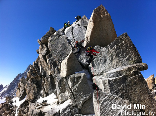
The Cosmiques Ridge is a supurb varied route which is justifiably popular. It is the perfect introduction to Alpine mixed climbing has enough variety to keep experienced climbers happy. The route is also known as the Cosmiques Arête and South-South-West Ridge. It's graded at AD but the crux is hard for its grade and suitable mixed climbing and abseiling skills are required. Much of the ridge can be climbed moving together, however the crux section will likely require a belay to be established. The rock is excellent quality throughout and there are plenty of locations to place protection.
It is possible to climb the ridge year round however poor snow conditions will make the route more difficult and dangerous. In poor conditions, descending from the cable station down to the Col du Midi can also be a nervous affair. Most people climb the route between June and September. The ridge was first climbed by George and Maxwell Finched on 2nd August 1911.
The route starts from the Abri Simond bivouac hut which is adjacent to the Cosmiques hut. The obvious way to reach the starting point is via the Aiguille du Midi-Vallee Blanche Cable car from Chamonix. From the cable car station, descend to the Col du Midi and then head for the Cosmiques Hut, bearing towards to Abri Simond as it comes into view. It's possible to climb the Cosmiques Ridge the same morning as having taken the cable car however there will be climbing traffic on the route which will likely slow you down.
The video of Mont Blanc climbing is here : youtu.be/3xAeVLIcFKw
Monday, July 23, 2012
Chamonix, Mont-Blanc - The Cosmiques Ridge
The Cosmiques Ridge is a supurb varied route which is justifiably popular. It is the perfect introduction to Alpine mixed climbing has enough variety to keep experienced climbers happy. The route is also known as the Cosmiques Arête and South-South-West Ridge. It's graded at AD but the crux is hard for its grade and suitable mixed climbing and abseiling skills are required. Much of the ridge can be climbed moving together, however the crux section will likely require a belay to be established. The rock is excellent quality throughout and there are plenty of locations to place protection.
It is possible to climb the ridge year round however poor snow conditions will make the route more difficult and dangerous. In poor conditions, descending from the cable station down to the Col du Midi can also be a nervous affair. Most people climb the route between June and September. The ridge was first climbed by George and Maxwell Finched on 2nd August 1911.
The route starts from the Abri Simond bivouac hut which is adjacent to the Cosmiques hut. The obvious way to reach the starting point is via the Aiguille du Midi-Vallee Blanche Cable car from Chamonix. From the cable car station, descend to the Col du Midi and then head for the Cosmiques Hut, bearing towards to Abri Simond as it comes into view. It's possible to climb the Cosmiques Ridge the same morning as having taken the cable car however there will be climbing traffic on the route which will likely slow you down.
Tuesday, July 17, 2012
Mont Blanc, Chamonix - Golden Ice
Chamonix is dominated by the white majestic dome of Mont Blanc, at 4,810m the highest mountain in western Europe.
Every year the summit of Mont Blanc becomes the ultimate objective for mountaineers the world over, all striving to stand on top of the roof of Europe and look down on all of the major summits of the Alps.
To climb Mont Blanc from Chamonix, people normally chose one of the two most common routes. Slightly more technical, the route from the Aiguille du Midi, over Mont Blanc du Tacul and Mont Maudit is generally quieter, and highly dependent on conditions.
The slightly easier and more reliable option is via the Tramway du Mont Blanc to the Nid d'Aigle, then up the Aiguille du Gouter and the Bosse ridge.
While not technically challenging, ascending Mont Blanc requires a high level of physical fitness and experience using crampons and an ice axe.
Thanks to Marie for this awesome shot !!!
Monday, July 16, 2012
Mont Blanc, Chamonix - Xtreme Climbing
Getty | Facebook Fan Page | Twitter | Google + | Blogger | Tumblr | Formspring
Mont Blanc or Monte Bianco (Italian), meaning "White Mountain", is the highest mountain in the Alps, Western Europe and the European Union. It rises 4,810.45 m above sea level and is ranked 11th in the world in topographic prominence.
The mountain lies in a range called the Graian Alps, between the regions of Aosta Valley, Italy, and Haute-Savoie, France. The location of the summit is on the watershed line between the valleys of Ferret and Veny in Italy and the Arve Valley in France.
The two most famous towns near Mont Blanc are Courmayeur in Aosta Valley, Italy, and Chamonix in Haute-Savoie, France—the site of the first Winter Olympics. A cable car ascends and crosses the mountain from Courmayeur to Chamonix.
The Mont Blanc massif is popular for mountaineering, hiking, skiing and snowboarding.
RIP to the 11 alpinists killed this week.
Thanks to Marie for this awesome shot !!!
Sunday, July 15, 2012
Mont Blanc - Chamonix

Mont Blanc or Monte Bianco (Italian), meaning "White Mountain", is the highest mountain in the Alps, Western Europe and the European Union. It rises 4,810.45 m above sea level and is ranked 11th in the world in topographic prominence.
The mountain lies in a range called the Graian Alps, between the regions of Aosta Valley, Italy, and Haute-Savoie, France. The location of the summit is on the watershed line between the valleys of Ferret and Veny in Italy and the Arve Valley in France.
The two most famous towns near Mont Blanc are Courmayeur in Aosta Valley, Italy, and Chamonix in Haute-Savoie, France—the site of the first Winter Olympics. A cable car ascends and crosses the mountain from Courmayeur to Chamonix.
The Mont Blanc massif is popular for mountaineering, hiking, skiing and snowboarding.
Tuesday, May 8, 2012
Annapurna, Nepal - Mount Machapuchare @Sunset
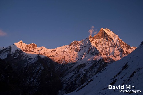
Machapuchare or Machhapuchhre (6 997m) meaning "Fish Tail" in English, is a mountain in the Annapurna Himalaya of north central Nepal. It is revered by the local population as particularly sacred to the god Shiva, and hence is off limits to climbing.
Machhapuchhre is at the end of a long spur ridge, coming south out of the main backbone of the Annapurna Himal, that forms the eastern boundary of the Annapurna Sanctuary. The Sanctuary is a favorite trekking destination, and the site of the base camps for the South Face of Annapurna and for numerous smaller objectives.
Due to its southern position in the range, and the particularly low terrain that lies south of the Annapurna Himal, Machapuchare commands tremendous vertical relief in a short horizontal distance. This, combined with its steep, pointed profile, make it a particularly striking peak, despite a lower elevation than some of its neighbors. Its double summit resembles the tail of a fish, hence the name meaning "Fish's Tail" in Nepali language It is also nicknamed the "Matterhorn of Nepal".
Machapuchare has never been climbed to its summit. The only attempt was in 1957 by a British team led by Jimmy Roberts. Climbers Wilfrid Noyce and A. D. M. Cox climbed to within 50 m of the summit via the north ridge, but did not complete the ascent; they had promised not to set foot on the actual summit. Since then, the mountain has been declared sacred, and it is now forbidden to climbers.
Saturday, March 3, 2012
Me skiing @ Les 3 Vallées, France

The largest ski resort in the world, without competition, is Les 3 Vallées in France with the major villages Val Thorens, Les Menuires, Meribel and Courchevel. Les 3 Vallées has 600 km of piste which no other linked ski area is close to.
In terms of general skiing conditions, the worlds' best ski resort has to be Whistler, one of the biggest and best in North America, attracting more skiers than any other resort in the world. The magnificent and highly developed all-round resort of Whlstler-Blackcomb, as it is now referred to, boasts two magical mountains full of amazing glaciers and bowls, incredible high-speed lifts, acres of expert and extreme skiing, together with a bright and vibrant village with immense charm - all key elements for the worlds' best ski resort. In Europe, a contender for the worlds' best ski resort would have to be Chamonix-Mont Blanc - its' notoriously challenging terrain comprising the worlds' biggest vertical of over 2,800m and the longest and best-known run in the Alps stretching for 22km. Some other notable challengers would be the ever-popular Vail, the largest single ski area in the US; Courcheval, offering the best skiing in the extensive Trois Vallees region; Kitzbuhel, for its major ski areas, combined with classic Tyrolean charm and accessibility, and Zermatt, with its' high altitude slopes and fairy-tale beauty.
Off the slopes, the worlds' best ski resorts for apres-ski would feature St. Anton and Val d'Isere for their young and lively non-stop party scene, and Aspen and Cortina, both towns known for vibrant and upscale establishments. For exclusivity and glamour, the worlds' best ski resorts would have to include Gstaad, St Moritz, and Lech - all known for a sophisticated atmosphere, jet-set image and stylish clientele. For all-round family-friendliness, the worlds' best ski resorts should feature the versatile resorts of Breckenridge, Les Arcs and Leysin, offering great facilities and plenty of varied terrain.
Wednesday, February 29, 2012
Kathmandu, Nepal - Swayambhunath Temple
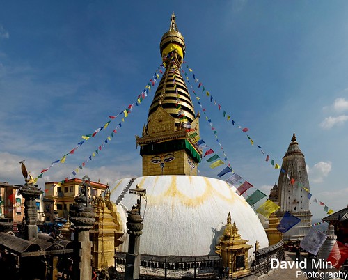
Swayambhunath is an ancient religious complex atop a hill in the Kathmandu Valley, west of Kathmandu city. It is also known as the Monkey Temple as there are holy monkeys living in parts of the temple in the north-west. The Tibetan name for the site means 'Sublime Trees', for the many varieties of trees found on the hill.
For the Buddhists, Swayambhunath occupies a central position, it is probably the most sacred among Buddhist pilgrimage sites. For Tibetans and followers of Tibetan Buddhism, it second only to Boudhanath.
The Swayambhunath complex consists of a stupa, a variety of shrines and temples, some dating back to the Licchavi period. A Tibetan monastery, museum and library are more recent additions. The stupa has Buddha's eyes and eyebrows painted on. Between them, there is something painted which looks like the nose - but is the Nepali symbol of 'unity', in the main Nepali language dialect.
Sunday, February 19, 2012
Me vs Annapurna
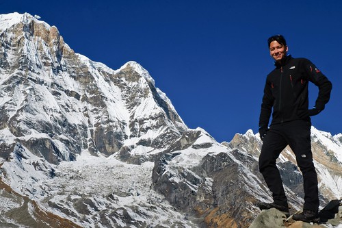
I think I've never posted a photo of me on Flickr but since I had this one I figured out why not.
1. I enjoy outdoors activities, hiking obviously one of them.
2. Since I made this awesome trek, I really want to climb a 7000m mountain !!!
3. As many people made the confusion during my last travel, I'm not nepali ;)
4. I can't get rid of the "Mantra of Avalokiteshvara" music from my mind since my return. This music can be heard everywhere, everytime in Nepal !!!
5. I live in Paris and I'm not a pilot, neither a traveler journalist ...
6. I don't like thinking of random things about me :-)
7. Ever since I got my D80, about 4 years ago, I've shot maybe 30 000 shots.
8. I love travelling. Maybe you do not know that :-)
9. I'm watching NCIS right now.
10. By the way, thanks for all your kind words and supportive comments on Flickr.
Friday, February 17, 2012
Annapurna Base Camp, Nepal - Frozen Morning
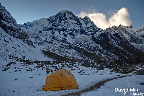
Annapurna is a section of the Himalayas in north-central Nepal that includes 8,091 metres (26,545 ft) Annapurna I, thirteen additional peaks over 7,000 m (22,970 ft) and 16 more over 6,000 m (19,690 ft).
The entire massif and surrounding area are protected within the 7,629 km2 Annapurna Conservation Area, the first and largest conservation area in Nepal. The Annapurna Conservation Area is home to several world-class treks, including the Annapurna Circuit.
The Annapurna peaks are the world's most dangerous mountains to climb although, from figures since 1990, Kangchenjunga surpasses Annapurna's death rate. As of 2007, there had been 153 summit ascents of Annapurna I, and 58 climbing fatalities on the mountain. This fatality to summit ratio (38%) is the highest of any of the eight-thousanders. In particular, the ascent via the south face is considered the most difficult of all climbs.
Monday, January 23, 2012
Lisbon, Portugal - Monasterio de los Jerónimos de Belém
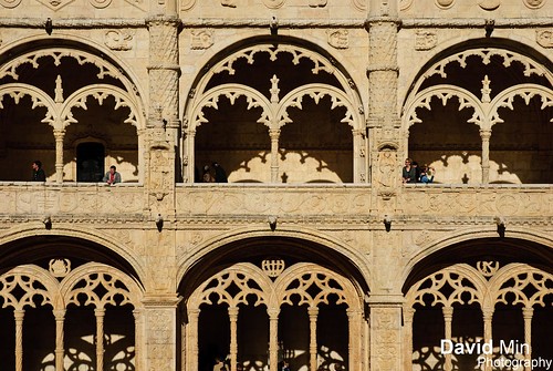
The Hieronymites Monastery is located near the shore of the parish of Belém, in the municipality of Lisbon, Portugal. The monastery is one of the most prominent monuments of the Manueline-style architecture in Lisbon, classified in 1983 as a UNESCO World Heritage Site, along with the nearby Tower of Belém.
The church and the monastery, like the nearby Torre de Belém and Padrão dos Descobrimentos, symbolise the Portuguese Age of Discovery and is among the main tourist attractions of Lisbon.
Saturday, January 14, 2012
Kathmandu, Nepal - Boudhanath Temple
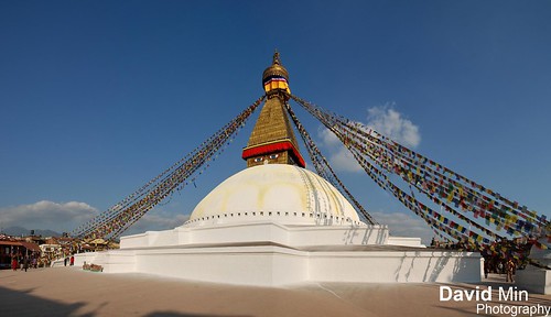
Boudhanath is one of the holiest Buddhist sites in Kathmandu, Nepal. Located about 11 km (6.8 mi) from the center and northeastern outskirts of Kathmandu, the stupa's massive mandala makes it one of the largest spherical stupas in Nepal.
The Buddhist stupa of Boudhanath dominates the skyline. The ancient Stupa is one of the largest in the world. The influx of large populations of refugees from Tibet has seen the construction of over 50 Tibetan Gompas (Monasteries) around Boudhanath. As of 1979, Boudhanath is a UNESCO World Heritage Site. Along with Swayambhunath, it is one of the most popular tourist sites in the Kathmandu area.
Wednesday, January 4, 2012
Lisbon, Portugal - Belém Tower
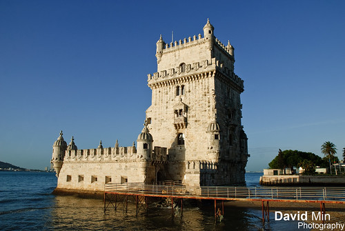
Belém Tower (in Portuguese Torre de Belém) or the Tower of St Vincent is a fortified tower located in the civil parish of Santa Maria de Belém in the municipality of Lisbon, Portugal. It is an UNESCO World Heritage Site (along with the nearby Jerónimos Monastery) because of the significant role it played in the Portuguese maritime discoveries of the era of the Age of Discoveries. The tower was commissioned by King John II to be part of a defense system at the mouth of the Tagus River and a ceremonial gateway to Lisbon.
The tower was built in the early 16th century and is a prominent example of the Portuguese Manueline style, but it also incorporates hints of other architectural styles. The structure was built from lioz limestone and is composed of a bastion and the 30 meter (100 foot), four story tower. It has incorrectly been stated that the tower was built in the middle of the Tagus and now sits near the shore because the river was redirected after the 1755 Lisbon earthquake. In fact, the tower was built on a small island in the Tagus River near the Lisbon shore.
Subscribe to:
Posts (Atom)