
Happy New Year !!!
Tuesday, December 31, 2013
Thursday, December 26, 2013
Vienna, Austria - Rathausplatz Christmas Market
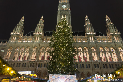
If you are lucky enough to go to Vienna in November or December, you must browse through the traditional Christmas markets that are located all throughout the city. There are many, but among them are the Schönbrunn (next to the famous palace), and, above all, located in the Town Hall Square, the very center of the city (getting there is easy, both metro and tram). many different items are on sale at this market, though it is devoted mainly to Christmas decorations and to candy. Toys, books, textiles and glass are some other products that you can find (on the web you can find a list). To combat the winter cold, it's best to try a typical Punsch (without alcohol) or Glühwein (although I admit that to me either I came to like too much), and go with some sweet. It's a good place to get lost in the city, especially for the evening, when all of the stalls are open and there is an especially fun atmosphere.
Saturday, October 19, 2013
Dead Sea, Jordan
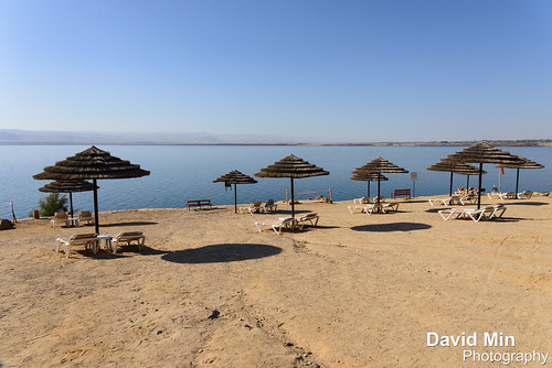
The Dead Sea, also called the Salt Sea, is a salt lake bordering Jordan to the east and Israel and Palestine to the west. Its surface and shores are 423 metres below sea level,Earth's lowest elevation on land. The Dead Sea is 377 m deep, the deepest hypersaline lake in the world. With 33.7% salinity, it is also one of the world's saltiest bodies of water, though Lake Assal (Djibouti), Garabogazköl and some hypersaline lakes of the McMurdo Dry Valleys in Antarctica have reported higher salinities. It is 9.6 times as salty as the ocean. This salinity makes for a harsh environment in which animals cannot flourish, hence its name. The Dead Sea is 55 kilometres long and 18 kilometres wide at its widest point. It lies in the Jordan Rift Valley, and its main tributary is the Jordan River.
The Dead Sea has attracted visitors from around the Mediterranean basin for thousands of years. Biblically, it was a place of refuge for King David. It was one of the world's first health resorts (for Herod the Great), and it has been the supplier of a wide variety of products, from balms for Egyptian mummification to potash for fertilizers. People also use the salt and the minerals from the Dead Sea to create cosmetics and herbal sachets.
The Dead Sea seawater has a density of 1.240 kg/L, which makes swimming similar to floating.
Monday, October 14, 2013
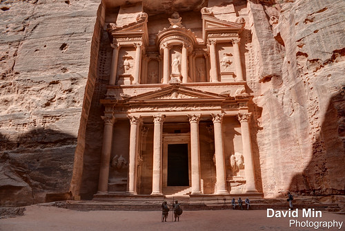
Petra, Jordan - Al Khazneh ("The Treasury")
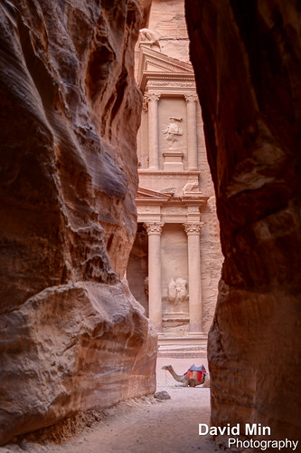
Al Khazneh ("The Treasury") is one of the most elaborate temples in the ancient Jordanian city of Petra. As with most of the other buildings in this ancient town, including the Monastery (Arabic: Ad Deir), this structure was carved out of a sandstone rock face. It has classical Greek-influenced architecture, and it is a popular tourist attraction. Al Khazneh was originally built as a mausoleum and crypt at the beginning of the 1st Century AD during the reign of Aretas IV Philopatris. Its Arabic name Treasury derives from one legend that bandits or pirates hid their loot in a stone urn high on the second level. Significant damage from bullets can be seen on the urn. Local lore attributes this to Bedouins, who are said to have shot at the urn in hopes of breaking it open and spilling out the "treasure"—but the decorative urn is in fact solid sandstone). Another is that it functioned as a treasury of the Egyptian Pharaoh at the time of Moses.
Many of the building's architectural details have eroded away during the two thousand years since it was carved and sculpted from the cliff. The sculptures are thought to be those of various mythological figures associated with the afterlife. On top are figures of four eagles that would carry away the souls. The figures on the upper level are dancing Amazons with double-axes. The entrance is flanked by statues of the twins Castor and Pollux who lived partly on Olympus and partly in the underworld.
Monday, September 30, 2013
Petra, Jordan - Al Khazneh ("The Treasury")
Al Khazneh ("The Treasury") is one of the most elaborate temples in the ancient Jordanian city of Petra. As with most of the other buildings in this ancient town, including the Monastery (Ad Deir), this structure was carved out of a sandstone rock face. It has classical Greek-influenced architecture, and it is a popular tourist attraction.
Al Khazneh was originally built as a mausoleum and crypt at the beginning of the 1st Century AD during the reign of Aretas IV Philopatris. Its Arabic name Treasury derives from one legend that bandits or pirates hid their loot in a stone urn high on the second level. Significant damage from bullets can be seen on the urn. Local lore attributes this to Bedouins, who are said to have shot at the urn in hopes of breaking it open and spilling out the "treasure"—but the decorative urn is in fact solid sandstone). Another is that it functioned as a treasury of the Egyptian Pharaoh at the time of Moses.
Many of the building's architectural details have eroded away during the two thousand years since it was carved and sculpted from the cliff. The sculptures are thought to be those of various mythological figures associated with the afterlife. On top are figures of four eagles that would carry away the souls. The figures on the upper level are dancing Amazons with double-axes. The entrance is flanked by statues of the twins Castor and Pollux who lived partly on Olympus and partly in the underworld.
Saturday, September 28, 2013
Madaba, Jordan - King Hussein Mosque

Madaba is the capital city of Madaba Governorate in central Jordan, which has a population of about 60,000. It is best known for its Byzantine and Umayyad mosaics, especially a large Byzantine-era mosaic map of The Holy Land. Madaba is located 30 kilometres south-west of the capital Amman.The first mosaics were discovered purely by chance during the building of the new permanent dwellings using squared-up stones from the old monuments.
The new inhabitants of Madaba, made conscious of the importance of the mosaics by their priests, made sure that they took care of and preserved all the mosaics that came to light.
The northern part of the city turned out to be the area containing the greatest concentration of mosaic monuments. During the Byzantine-Umayyad period, this northern area, crossed by a colonnaded Roman road, saw the building of the Church of the Map, the Hippolytus Mansion, the Church of the Virgin Mary, the Church of Prophet Elijah with its crypt, the Church of the Holy Martyrs (Al-Khadir), the Burnt Palace and the Church of the Sunna' family.
Wednesday, September 25, 2013
Petra, Jordan - Ad Deir ("The Monastery")

Petra is a historical and archaeological city in the southern Jordanian governorate of Ma'an, that is famous for its rock-cut architecture and water conduit system. Another name for Petra is the Rose City due to the color of the stone out of which it is carved.
Established possibly as early as 312 BCE as the capital city of the Nabataeans, it is a symbol of Jordan, as well as its most-visited tourist attraction. Petra has been a UNESCO World Heritage Site since 1985.
The site remained unknown to the Western world until 1812, when it was introduced by Swiss explorer Johann Ludwig Burckhardt. It was described as "a rose-red city half as old as time" in a Newdigate Prize-winning poem by John William Burgon. UNESCO has described it as "one of the most precious cultural properties of man's cultural heritage".
Ad Deir ("The Monastery") is a monumental building carved out of rock in the ancient Jordanian city of Petra. Built by the Nabataeans in the 1st century and measuring 50 metres wide by approximately 45 meters high, architecturally the Monastery is an example of the Nabatean Classical style. It is the second most visited building in Petra after Al Khazneh.
Sunday, September 8, 2013
Prague, Czech Republic - Old Town Plaza
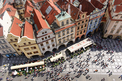
Old Town is a medieval settlement of Prague, Czech Republic. It was separated from the outside by a semi-circular moat and wall, connected to the Vltava at both of its ends. The moat is now covered up by the streets Revolučni, Na Příkopě, and Národni—which remain the official boundary of the cadastral district of Old Town. It is now in Praha 1.
Soon after the city was expanded in the 14th century by Charles IV with the founding of the New Town, the moat and wall were dismantled.
Notable places in the Old Town include the Old New Synagogue, Old Town Square and Astronomical Clock. Across the river Vltava connected by the Charles Bridge is Malá Strana. Josefov is located in the northwest corner of Old Town heading towards the Vltava.
Sunday, September 1, 2013
Prague, Czech Republic - Prague Castle
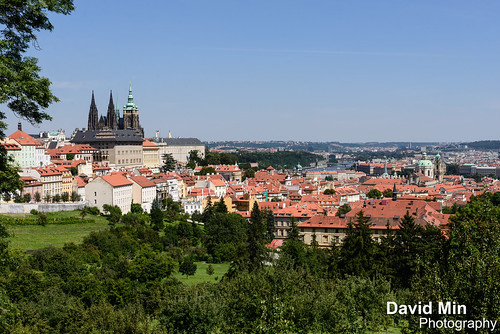
Prague Castle is a castle in Prague where the Kings of Bohemia, Holy Roman Emperors and presidents of Czechoslovakia and the Czech Republic have had their offices. The Bohemian Crown Jewels are kept within a hidden room inside it.
The Guinness Book of Records lists Prague Castle as the largest ancient castle in the world. It occupies an area of almost 70 000 m², at about 570 metres in length and an average of about 130 metres wide. The castle buildings represent virtually every architectural style of the last millennium. The Prague Castle includes Gothic St Vitus Cathedral, Romanesque Basilica of St. George, a monastery and several palaces, gardens and defense towers. Most of the castle areas are open to tourists.
Saturday, August 24, 2013
Prague, Czech Republic - Prague Castle

Prague Castle is a castle in Prague where the Kings of Bohemia, Holy Roman Emperors and presidents of Czechoslovakia and the Czech Republic have had their offices. The Bohemian Crown Jewels are kept within a hidden room inside it.
The Guinness Book of Records lists Prague Castle as the largest ancient castle in the world. It occupies an area of almost 70 000 m², at about 570 metres in length and an average of about 130 metres wide.
The castle buildings represent virtually every architectural style of the last millennium. The Prague Castle includes Gothic St Vitus Cathedral, Romanesque Basilica of St. George, a monastery and several palaces, gardens and defense towers. Most of the castle areas are open to tourists.
Sunday, August 18, 2013
Prague, Czech Republic - Charles Bridge
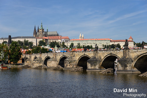
The Charles Bridge is a famous historic bridge that crosses the Vltava river in Prague, Czech Republic. Its construction started in 1357 under the auspices of King Charles IV, and finished in the beginning of the 15th century. The bridge replaced the old Judith Bridge built 1158-1172 that had been badly damaged by a flood in 1342. This new bridge was originally called the Stone Bridge or the Prague Bridge but has been the "Charles Bridge" since 1870. As the only means of crossing the river Vltava until 1841, the Charles Bridge was the most important connection between Prague Castle and the city's Old Town and adjacent areas. This "solid-land" connection made Prague important as a trade route between Eastern and Western Europe.
The bridge is 621 m long and nearly 10 m wide, resting on 16 arches shielded by ice guards. It is protected by three bridge towers, two of them on the Lesser Quarter side and the third one on the Old Town side. The Old Town bridge tower is often considered to be one of the most astonishing civil gothic-style buildings in the world. The bridge is decorated by a continuous alley of 30 statues and statuaries, most of them baroque-style, originally erected around 1700 but now all replaced by replicas.
Sunday, July 14, 2013
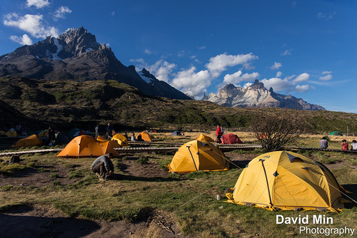
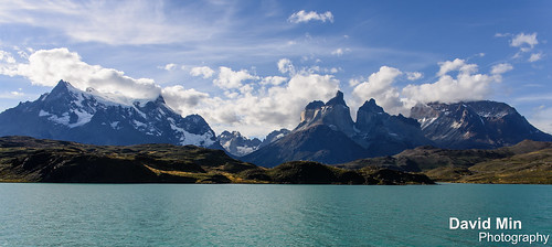
Torres Del Paine, Chile
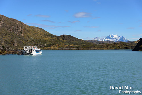
Torres del Paine is a national park in the Extreme South region of Patagonian Chile. It is located in the southern tiers of the Andes and features mountains, lakes and glaciers.
The Torres del Paine (Spanish for "Towers of Paine" and "Paine" is the old indigenos name for the colour blue), three immense rock towers give the park its name.
Other attractions include the Cuernos del Paine (Spanish for "Horns of Paine" -- horn-like mountain tops), Grey Glacier, Lago Grey, Lago Pehoe, Lago Nordenskjöld and Lago Sarmiento. Jutting out some 2800m above the Patagonian steppe, the Torres del Paine (Towers of Paine) are spectacular granite pillars that dominate the landscape of what may be South America's finest national park. These breathtaking spires are flanked by the summit of Paine Grande (3050m) and the sharp tusks of black sedimentary peaks known as Los Cuernos (The Horns; 2200m to 2600m). Yes, these are the famous Patagonian mountains that you see on posters and book covers all over the world.
But the park is not just mountains. Trails meander through emerald forests, alongside and over roaring rivers, past radiant blue glaciers, azure lakes and up to jaw-dropping lookouts. You can hike into the vast openness of the steppe, heading to less-visited lakes and glaciers, all the while keeping an eye on the looming peaks. That is when the weather is clear. Unpredictable at best, weather systems can sheath the peaks in veils of clouds that hold for hours, if not days. Even then, the park has its allure - but it is always wise to plan a few extra days to make sure that your trip isn't torpedoed by a spot of bad weather.
Tuesday, June 18, 2013
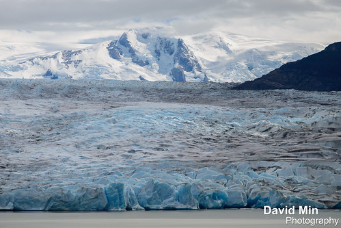
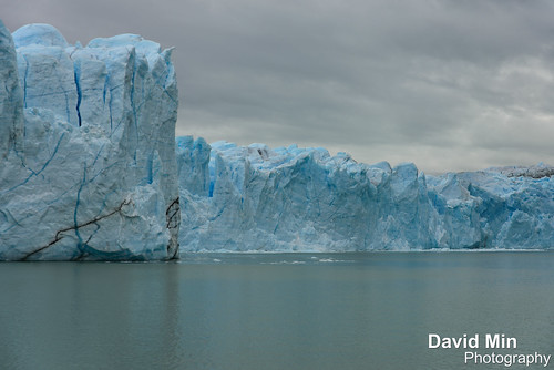
El Calafate, Argentina - Perito Moreno Glacier
The Perito Moreno Glacier is a glacier located in the Los Glaciares National Park in south west Santa Cruz province, Argentina. It is one of the most important tourist attractions in the Argentine Patagonia.
The 250 km2 ice formation, and 30 km in length, is one of 48 glaciers fed by the Southern Patagonian Ice Field located in the Andes system shared with Chile. This icefield is the world's third largest reserve of fresh water.
The Perito Moreno glacier, located 78 kilometres from El Calafate, was named after the explorer Francisco Moreno, a pioneer who studied the region in the 19th century and played a major role in defending the territory of Argentina in the conflict surrounding the international border dispute with Chile. The Perito Moreno Glacier is one of only three Patagonian glaciers that is growing. The reason remains debated by glaciologists.The terminus of the Perito Moreno Glacier is 5 kilometres wide, with an average height of 74 m above the surface of the water of Lake Argentino, in Argentina. It has a total ice depth of 170 metres. Pressures from the weight of the ice slowly pushes the glacier over the southern arm of "Lago Argentino" damming the section and separating it from the rest of the lake. With no outlet, the water-level on the "Brazo Rico" side of the lake can rise by as much as 30 meters above the level of the main body of Lake Argentina. Periodically, the pressure produced by the height of the dammed water breaks through the ice barrier causing a spectacular rupture, sending a massive outpouring of water from the Brazo Rico section to the main body of Lake Argentina. Due to its size and accessibility, Perito Moreno is one of the major tourist attractions in southern Patagonia. It is less than two hours by bus from El Calafate, and many tour companies run daily visits. A large visitor centre at the site features a walking circuit which allows visitors to view the southern flank and the east facing edge of the glacier.
In recent years, trekking tours on the ice have gained popularity. The two standard tours are a "mini-trekking" option, consisting of a short walk of about an hour and a half, and a "big ice" version, which is usually about five hours. Tour companies generally provide crampons to customers.
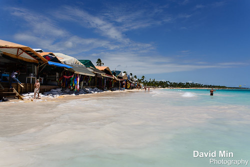
Saturday, June 15, 2013
Cabrera, Dominican Republic - Playa Grande Beach
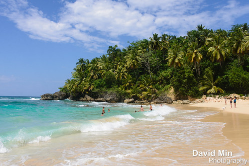
Cabrera is considered one of the most beautiful places in the Dominican Republic. Located facing the Atlantic, Cabrera has one of the most beautiful beaches, rivers, exotic vegetation and many natural attractions. A National Park reserve is located in El Breton, a small section of Cabrera called Cabo Frances Viejo. The most attractive beach in the area is Playa Grande (Big Beach), cited by Condé Nast Traveler as one of the most beautiful beaches in the world. Other local beaches include Playa Precioso, El Diamante (Diamond Beach), Playa La Entrada, El Caleton de Dario (Orchid Bay Beach), El Caleton del Medio, and El Caleton Chiquito.
Sunday, June 9, 2013
Ushuaia, Argentina - Les Eclaireurs Lighthouse

Les Eclaireurs Lighthouse (the French name "Les Éclaireurs" means "the Enlighteners") is a slightly conically shaped lighthouse standing on the northeastern-most islet of the five or more Les Eclaireurs islets, which it takes its name from, 5 Nautical mile east of Ushuaia in the Beagle Channel, Tierra del Fuego, southern Argentina.
The brick-built tower is 10 metres high and 3 metres wide at the base, with its windowless wall painted red-white-red and topped by a black lantern housing and gallery. Only a door pointing to the west provides access to the building. The light is 22.5 metres above sealevel emitting white flashes every ten seconds with a range of 7.5 nautical miles (13.9 km). The lighthouse, still in operation, is remote-controlled, automated, uninhabited, and not open to the public, guarding the sea entrance to Ushuaia. Electricity is supplied by solar-panels. On December 23, 1920 the lighthouse was put into service - today probably the most photographed lighthouse in South America.
It is a popular tourist attraction, reached on short boat tours from Ushuaia. It is known to the Argentines as the Lighthouse at the End of the World (Faro del fin del mundo), although that name is misleading. The lighthouse is often confused with the San Juan de Salvamento lighthouse on the east coast of the remote Isla de los Estados, made famous by Jules Verne in the novel The Lighthouse at the End of the World, which is actually much further east.
Sunday, June 2, 2013
Paris, France - Sout Africa Season Lights Up Eiffel Tower
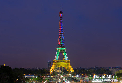
THE EIFFEL Tower in Paris has had a Mzansi make-over – it has been lit up in the colours of our flag – to launch The South African Season in France. The tower will stay lit in the South African flag colours for a week, and will then be re-lit in the same way in the week leading up to Nelson Mandela’s birthday.
Alongside Nelson Mandela Day and the Nelson Mandela Exhibition, SA Season organisers will promote the 67 minutes of activism programme to encourage the French to spend time helping those less fortunate than themselves.
Friday, May 24, 2013
Chile, Torres Del Paine - Lake Grey
Grey lake is a beautiful show of nature for visitors from around the world. Its waters –recovered by sediments in the surface-, and the Paine Mountain behind it, turn it into a postcard worthy picture.
It has more than 500 meters of depth, surrounded by incredible rocky attractions. It was born from the Southern Patagonia Ice Field, and it is the birhtplace of huge icebergs detachment from Grey Glacier.
Its gray waters are ideal to practice kayak and canoe, among other entertaining activities you can do around the place.
Sunday, May 19, 2013
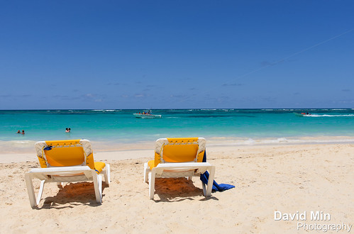
Punta Cana, Dominican Republic - Bavaro Beach
Bávaro is a touristic area in Punta Cana, located in La Altagracia province, the easternmost province of the Dominican Republic. Bavaro was developed together with the resort area and tourist region of Punta Cana, as a town for resort workers. As hotels started to rise along the east coast, north from Punta Cana, Bavaro itself became a center of services.
The area of Punta Cana is best known for its beaches and balnearios, which face both the Caribbean and Atlantic, and it has been a popular tourist destination since the 1970s. The weather is fairly consistent all year, with an average temperature of 30 °C (86 °F). The hot and humid season lasts from May to October, and during the day temperatures might reach 35 °C (95 °F). From November to March, temperatures during the evening are around 20 °C (68 °F). Very little rain falls around the area, primarily because of the mostly flat landscape, a combination of savanna and mountains.
Punta Cana, part of the newly Punta Cana-Bavaro county, is considered the major resort area in the Dominican Republic with 28,000 hotel rooms.
Monday, May 13, 2013
Punta Cana, Dominican Republic - Bavaro Beach
Bávaro is a touristic area in Punta Cana, located in La Altagracia province, the easternmost province of the Dominican Republic. Bavaro was developed together with the resort area and tourist region of Punta Cana, as a town for resort workers. As hotels started to rise along the east coast, north from Punta Cana, Bavaro itself became a center of services.
The area of Punta Cana is best known for its beaches and balnearios, which face both the Caribbean and Atlantic, and it has been a popular tourist destination since the 1970s. The weather is fairly consistent all year, with an average temperature of 30 °C (86 °F). The hot and humid season lasts from May to October, and during the day temperatures might reach 35 °C (95 °F). From November to March, temperatures during the evening are around 20 °C (68 °F). Very little rain falls around the area, primarily because of the mostly flat landscape, a combination of savanna and mountains.
Punta Cana, part of the newly Punta Cana-Bavaro county, is considered the major resort area in the Dominican Republic with 28,000 hotel rooms.
Tuesday, April 30, 2013
Torres Del Paine, Chile
Torres del Paine is a national park in the Extreme South region of Patagonian Chile. It is located in the southern tiers of the Andes and features mountains, lakes and glaciers.
The Torres del Paine (Spanish for "Towers of Paine" and "Paine" is the old indigenos name for the colour blue), three immense rock towers give the park its name.
Other attractions include the Cuernos del Paine (Spanish for "Horns of Paine" -- horn-like mountain tops), Grey Glacier, Lago Grey, Lago Pehoe, Lago Nordenskjöld and Lago Sarmiento. Jutting out some 2800m above the Patagonian steppe, the Torres del Paine (Towers of Paine) are spectacular granite pillars that dominate the landscape of what may be South America's finest national park (admission high/low season US$17/8.50). These breathtaking spires are flanked by the summit of Paine Grande (3050m) and the sharp tusks of black sedimentary peaks known as Los Cuernos (The Horns; 2200m to 2600m). Yes, these are the famous Patagonian mountains that you see on posters and book covers all over the world.
But the park is not just mountains. Trails meander through emerald forests, alongside and over roaring rivers, past radiant blue glaciers, azure lakes and up to jaw-dropping lookouts. You can hike into the vast openness of the steppe, heading to less-visited lakes and glaciers, all the while keeping an eye on the looming peaks. That is when the weather is clear. Unpredictable at best, weather systems can sheath the peaks in veils of clouds that hold for hours, if not days. Even then, the park has its allure - but it is always wise to plan a few extra days to make sure that your trip isn't torpedoed by a spot of bad weather.
Saturday, April 27, 2013
Koh Phi Phi Leh, Thailand - Maya Bay
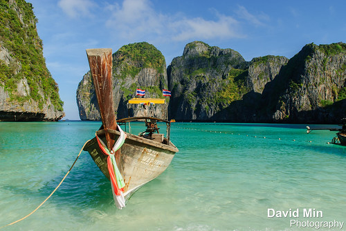
Maya Bay is a stunningly beautiful bay that's sheltered by 100-metre high cliffs on three sides. Inside the bay there are several beaches, most are small and some only exist at low tide. The main one is around 200 metres long with silky soft white sand, underwater colourful coral and exotic fish in exceptionally clear water; the whole bay is one big reef.
Maya Bay has become the main tourist attraction of Phi Phi since The Beach was filmed here in 1999. It was always very popular before the film but now people around the world who haven't even heard of Phi Phi have certainly heard of Maya Bay.
The bad news; as it's so beautiful and so well known many boats are required to ferry all the visitors in and out. On any given day at any time there will be 30 + speedboats and longtail boats on the beach, with large ferry boats carrying hundreds of snorkelers and sightseers moored in deeper water. Beautiful it is, secluded it isn't – thousands of people visit each day. Try to visit early in the morning or after 17:00 and you'll avoid the crowds.
Friday, April 19, 2013
Tokyo, Japan - Shibuya Crossing

Shibuya is one of the twenty-three city wards of Tokyo, but often refers to just the popular shopping and entertainment area found around Shibuya Station. In this regard, Shibuya is one of Tokyo's most colorful and busy districts, packed with shopping, dining and nightclubs serving swarms of visitors that come to the district everyday.
Shibuya is a center for youth fashion and culture, and its streets are the birthplace to many of Japan's fashion and entertainment trends. Over a dozen major department store branches can be found around the area catering to all types of shoppers. Most of the area's large department and fashion stores belong to either Tokyu or Seibu, two competing corporations.
It would be a shame to come to Tokyo and not take a walk across the famous intersection outside Shibuya Station. On sunny afternoons or clear evenings, the surrounding area is packed with shoppers, students, young couples and commuters. When the lights turn red at this busy junction, they all turn red at the same time in every direction. Traffic stops completely and pedestrians surge into the intersection from all sides, like marbles spilling out of a box. You can observe this moment of organized chaos from the second-story window of the Starbucks in the Tsutaya building on the crossing's north side.
Wednesday, April 17, 2013
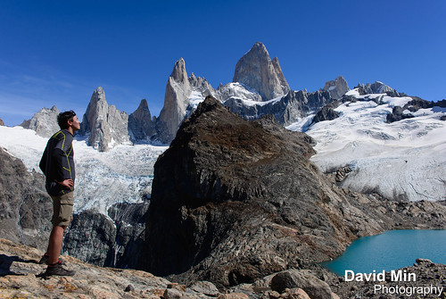
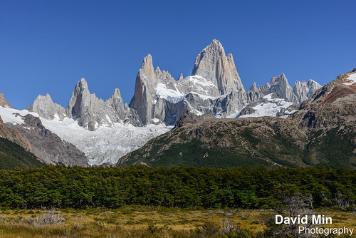
El Chalten, Argentina - Sunrise over Mount Fitz Roy

Mount Fitz Roy (3 359 m) is a mountain located near El Chaltén village, in the Southern Patagonian Ice Field in Patagonia, on the border between Argentina and Chile. First climbed in 1952 by French alpinists Lionel Terray and Guido Magnone, it remains among the most technically challenging mountains on Earth for mountaineers. Monte Fitz Roy is the basis for the Patagonia clothing logo following Yvon Chouinard's ascent and subsequent film in 1968.
The mountain has a reputation of being "ultimate", despite its average height (although being the highest peak in the Los Glaciares park, it is less than half the size of the Himalayan giants), because the sheer granite faces present long stretches of arduous technical climbing. In addition, the weather in the area is exceptionally inclement and treacherous. It also attracts many photographers thanks to its otherworldly shape.
The area, while still fairly inaccessible, was even more isolated until the recent development of El Chaltén village and El Calafate international airport. The mountain climb, however, remains extremely difficult and is the preserve of very experienced climbers. Today, when a hundred people may reach the summit of Mount Everest in a single day, Monte Fitz Roy may only be successfully ascended once a year.
Tuesday, April 9, 2013
El Calafate, Argentina - Ice Breaking @Perito Moreno Glacier

El Calafate, Argentina - Ice Breaking @Perito Moreno Glacier, a photo by GlobeTrotter 2000 on Flickr.
The Perito Moreno Glacier is a glacier located in the Los Glaciares National Park in south west Santa Cruz province, Argentina. It is one of the most important tourist attractions in the Argentine Patagonia. The 250 km2 ice formation, and 30 km in length, is one of 48 glaciers fed by the Southern Patagonian Ice Field located in the Andes system shared with Chile. This icefield is the world's third largest reserve of fresh water.
The Perito Moreno glacier, located 78 kilometres from El Calafate, was named after the explorer Francisco Moreno, a pioneer who studied the region in the 19th century and played a major role in defending the territory of Argentina in the conflict surrounding the international border dispute with Chile. The Perito Moreno Glacier is one of only three Patagonian glaciers that is growing. The reason remains debated by glaciologists.The terminus of the Perito Moreno Glacier is 5 kilometres wide, with an average height of 74 m above the surface of the water of Lake Argentino, in Argentina. It has a total ice depth of 170 metres.
Pressures from the weight of the ice slowly pushes the glacier over the southern arm ("Brazo Rico") of "Lago Argentino" ("Lake Argentina") damming the section and separating it from the rest of the lake. With no outlet, the water-level on the "Brazo Rico" side of the lake can rise by as much as 30 meters above the level of the main body of Lake Argentina. Periodically, the pressure produced by the height of the dammed water breaks through the ice barrier causing a spectacular rupture, sending a massive outpouring of water from the Brazo Rico section to the main body of Lake Argentina.
Due to its size and accessibility, Perito Moreno is one of the major tourist attractions in southern Patagonia. It is less than two hours by bus from El Calafate, and many tour companies run daily visits. A large visitor centre at the site features a walking circuit which allows visitors to view the southern flank and the east facing edge of the glacier.
In recent years, trekking tours on the ice have gained popularity. The two standard tours are a "mini-trekking" option, consisting of a short walk of about an hour and a half, and a "big ice" version, which is usually about five hours. Tour companies generally provide crampons to customers.
Monday, April 8, 2013
Siem Reap, Cambodia - Angkor Thom, Entry Tower

Angkor Thom is undeniably an expression of the highest genius. It is, in three dimensions and on a scale worthy of an entire nation, the materialization of Buddhist cosmology, representing ideas that only great painters would dare to portray.
Angkor Thom, the last capital of the Khmer Empire, was a fortified cit enclosing residences of priest, officials of the palace and military, as well as buildings for administering the kingdom. Through here all comers to the city had to pass, and in honor of this function it has been built in a style grandiose and elegant, forming a whole, incomparable in its strength and expression.
The five entry towers are among the most photographed of all the ancient Cambodian ruins. Each sandstone tower rises 23 meters (75 feet) to the sky and is crowned with four heads, one facing each cardinal direction. The faces may represent the rulers of the four cardinal points at the summit of mount Meru.
The lower half of each gate is modeled like an elephant with three heads. Their trunks, which serve as pillars, are plucking lotus flowers. The Hindu god Indra sits at the center of the elephant with an Apsara on each side. He holds a thunderbolt in his lower left hand.
Looking through the tower one can see a corbel arch, a hallmark of Khmer architecture. Inside, wooden crossbeams are visible and a sentry box stands on each side.
Saturday, April 6, 2013
El Chalten, Argentina - Me vs Fitz Roy
Mount Fitz Roy (3 359 m) is a mountain located near El Chaltén village, in the Southern Patagonian Ice Field in Patagonia, on the border between Argentina and Chile. First climbed in 1952 by French alpinists Lionel Terray and Guido Magnone, it remains among the most technically challenging mountains on Earth for mountaineers. Monte Fitz Roy is the basis for the Patagonia clothing logo following Yvon Chouinard's ascent and subsequent film in 1968.
The mountain has a reputation of being "ultimate", despite its average height (although being the highest peak in the Los Glaciares park, it is less than half the size of the Himalayan giants), because the sheer granite faces present long stretches of arduous technical climbing. In addition, the weather in the area is exceptionally inclement and treacherous. It also attracts many photographers thanks to its otherworldly shape. The area, while still fairly inaccessible, was even more isolated until the recent development of El Chaltén village and El Calafate international airport. The mountain climb, however, remains extremely difficult and is the preserve of very experienced climbers. Today, when a hundred people may reach the summit of Mount Everest in a single day, Monte Fitz Roy may only be successfully ascended once a year.
Thursday, April 4, 2013
Zanzibar, Tanzania - Tropical Paradise

Zanzibar is the collective name for two islands in the Indian Ocean: Unguja (the main island) and Pemba Island. The capital of Zanzibar, located on the island of Unguja, is Zanzibar City. The city's old quarter, known as Stone Town, is a Unesco World Heritage Site.
Zanzibar is characterised by beautiful sandy beaches with fringing coral reefs, and the magic of historic Stone Town, said to be the only functioning ancient town in East Africa. The coral reefs that surround the east coast are rich in marine diversity.
Monday, April 1, 2013
Torres Del Paine, Chile
Torres del Paine is a national park in the Extreme South region of Patagonian Chile. It is located in the southern tiers of the Andes and features mountains, lakes and glaciers.
The Torres del Paine (Spanish for "Towers of Paine" and "Paine" is the old indigenos name for the colour blue), three immense rock towers give the park its name.
Other attractions include the Cuernos del Paine (Spanish for "Horns of Paine" -- horn-like mountain tops), Grey Glacier, Lago Grey, Lago Pehoe, Lago Nordenskjöld and Lago Sarmiento. Jutting out some 2800m above the Patagonian steppe, the Torres del Paine (Towers of Paine) are spectacular granite pillars that dominate the landscape of what may be South America's finest national park (admission high/low season US$17/8.50). These breathtaking spires are flanked by the summit of Paine Grande (3050m) and the sharp tusks of black sedimentary peaks known as Los Cuernos (The Horns; 2200m to 2600m). Yes, these are the famous Patagonian mountains that you see on posters and book covers all over the world.
But the park is not just mountains. Trails meander through emerald forests, alongside and over roaring rivers, past radiant blue glaciers, azure lakes and up to jaw-dropping lookouts. You can hike into the vast openness of the steppe, heading to less-visited lakes and glaciers, all the while keeping an eye on the looming peaks. That is when the weather is clear. Unpredictable at best, weather systems can sheath the peaks in veils of clouds that hold for hours, if not days. Even then, the park has its allure - but it is always wise to plan a few extra days to make sure that your trip isn't torpedoed by a spot of bad weather.
Thursday, March 28, 2013
Torres del Paine, Chile - Fox
Torres del Paine is a national park in the Extreme South region of Patagonian Chile. It is located in the southern tiers of the Andes and features mountains, lakes and glaciers.
The Torres del Paine (Spanish for "Towers of Paine" and "Paine" is the old indigenos name for the colour blue), three immense rock towers give the park its name.
Other attractions include the Cuernos del Paine (Spanish for "Horns of Paine" -- horn-like mountain tops), Grey Glacier, Lago Grey, Lago Pehoe, Lago Nordenskjöld and Lago Sarmiento. Jutting out some 2800m above the Patagonian steppe, the Torres del Paine (Towers of Paine) are spectacular granite pillars that dominate the landscape of what may be South America's finest national park (admission high/low season US$17/8.50). These breathtaking spires are flanked by the summit of Paine Grande (3050m) and the sharp tusks of black sedimentary peaks known as Los Cuernos (The Horns; 2200m to 2600m). Yes, these are the famous Patagonian mountains that you see on posters and book covers all over the world.
But the park is not just mountains. Trails meander through emerald forests, alongside and over roaring rivers, past radiant blue glaciers, azure lakes and up to jaw-dropping lookouts. You can hike into the vast openness of the steppe, heading to less-visited lakes and glaciers, all the while keeping an eye on the looming peaks. That is when the weather is clear. Unpredictable at best, weather systems can sheath the peaks in veils of clouds that hold for hours, if not days. Even then, the park has its allure - but it is always wise to plan a few extra days to make sure that your trip isn't torpedoed by a spot of bad weather.
Sunday, March 24, 2013
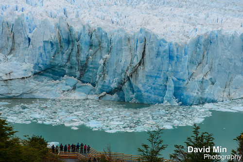
El Calafate, Argentina - Perito Moreno Glacier

To give you an idea, the explosion is as high as the first floor of the Eiffel Tower !
The Perito Moreno Glacier is a glacier located in the Los Glaciares National Park in south west Santa Cruz province, Argentina. It is one of the most important tourist attractions in the Argentine Patagonia. The 250 km2 ice formation, and 30 km in length, is one of 48 glaciers fed by the Southern Patagonian Ice Field located in the Andes system shared with Chile. This icefield is the world's third largest reserve of fresh water.
The Perito Moreno glacier, located 78 kilometres from El Calafate, was named after the explorer Francisco Moreno, a pioneer who studied the region in the 19th century and played a major role in defending the territory of Argentina in the conflict surrounding the international border dispute with Chile. The Perito Moreno Glacier is one of only three Patagonian glaciers that is growing. The reason remains debated by glaciologists.The terminus of the Perito Moreno Glacier is 5 kilometres wide, with an average height of 74 m above the surface of the water of Lake Argentino, in Argentina. It has a total ice depth of 170 metres.
Pressures from the weight of the ice slowly pushes the glacier over the southern arm ("Brazo Rico") of "Lago Argentino" ("Lake Argentina") damming the section and separating it from the rest of the lake. With no outlet, the water-level on the "Brazo Rico" side of the lake can rise by as much as 30 meters above the level of the main body of Lake Argentina. Periodically, the pressure produced by the height of the dammed water breaks through the ice barrier causing a spectacular rupture, sending a massive outpouring of water from the Brazo Rico section to the main body of Lake Argentina.
Due to its size and accessibility, Perito Moreno is one of the major tourist attractions in southern Patagonia. It is less than two hours by bus from El Calafate, and many tour companies run daily visits. A large visitor centre at the site features a walking circuit which allows visitors to view the southern flank and the east facing edge of the glacier.
In recent years, trekking tours on the ice have gained popularity. The two standard tours are a "mini-trekking" option, consisting of a short walk of about an hour and a half, and a "big ice" version, which is usually about five hours. Tour companies generally provide crampons to customers.
Friday, March 22, 2013
El Calafate, Argentina - Perito Moreno Explosion
El Calafate, Argentina - Perito Moreno Explosion a video by GlobeTrotter 2000 on Flickr.
The Perito Moreno Glacier is a glacier located in the Los Glaciares National Park in south west Santa Cruz province, Argentina. It is one of the most important tourist attractions in the Argentine Patagonia. The 250 km2 ice formation, and 30 km in length, is one of 48 glaciers fed by the Southern Patagonian Ice Field located in the Andes system shared with Chile. This icefield is the world's third largest reserve of fresh water.
The Perito Moreno glacier, located 78 kilometres from El Calafate, was named after the explorer Francisco Moreno, a pioneer who studied the region in the 19th century and played a major role in defending the territory of Argentina in the conflict surrounding the international border dispute with Chile. The Perito Moreno Glacier is one of only three Patagonian glaciers that is growing. The reason remains debated by glaciologists.The terminus of the Perito Moreno Glacier is 5 kilometres wide, with an average height of 74 m above the surface of the water of Lake Argentino, in Argentina. It has a total ice depth of 170 metres.
Pressures from the weight of the ice slowly pushes the glacier over the southern arm ("Brazo Rico") of "Lago Argentino" ("Lake Argentina") damming the section and separating it from the rest of the lake. With no outlet, the water-level on the "Brazo Rico" side of the lake can rise by as much as 30 meters above the level of the main body of Lake Argentina. Periodically, the pressure produced by the height of the dammed water breaks through the ice barrier causing a spectacular rupture, sending a massive outpouring of water from the Brazo Rico section to the main body of Lake Argentina.
Due to its size and accessibility, Perito Moreno is one of the major tourist attractions in southern Patagonia. It is less than two hours by bus from El Calafate, and many tour companies run daily visits. A large visitor centre at the site features a walking circuit which allows visitors to view the southern flank and the east facing edge of the glacier.
In recent years, trekking tours on the ice have gained popularity. The two standard tours are a "mini-trekking" option, consisting of a short walk of about an hour and a half, and a "big ice" version, which is usually about five hours. Tour companies generally provide crampons to customers.
Thursday, March 21, 2013
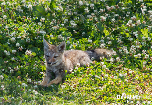
Torres Del Paine, Chile - Guanaco

The guanaco is a vulnerable animal native to the arid, mountainous regions of South America. Guanaco are found in the altiplano of Peru, Bolivia, Ecuador, Colombia, Chile and Argentina. In Argentina, they are more numerous in Patagonian regions, in places like the Torres del Paine National Park, and Isla Grande de Tierra del Fuego. In these areas, they have more robust populations, since there are limitations on grazing competition from livestock.
Torres del Paine is a national park in the Extreme South region of Patagonian Chile. It is located in the southern tiers of the Andes and features mountains, lakes and glaciers.
The Torres del Paine (Spanish for "Towers of Paine" and "Paine" is the old indigenos name for the colour blue), three immense rock towers give the park its name.
Other attractions include the Cuernos del Paine (Spanish for "Horns of Paine" -- horn-like mountain tops), Grey Glacier, Lago Grey, Lago Pehoe, Lago Nordenskjöld and Lago Sarmiento. Jutting out some 2800m above the Patagonian steppe, the Torres del Paine (Towers of Paine) are spectacular granite pillars that dominate the landscape of what may be South America's finest national park (admission high/low season US$17/8.50). These breathtaking spires are flanked by the summit of Paine Grande (3050m) and the sharp tusks of black sedimentary peaks known as Los Cuernos (The Horns; 2200m to 2600m). Yes, these are the famous Patagonian mountains that you see on posters and book covers all over the world.
Tuesday, March 19, 2013
Torres Del Paine, Chile - Fire In The Sky Over My Estancia
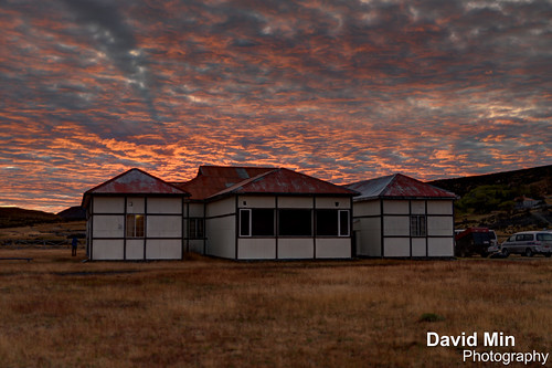
Estancia is a Spanish and Brazilian Portuguese term describing a large rural estate with similarities to the English term ranch. The term is used in Argentina, Uruguay, southern Chile and southern Brazil. The equivalent in other Latin American countries would be hacienda.
Unlike a hacienda, which could be any type of agricultural venture, producing grain, coffee, vegetable, beef, etc., an estancia, most typically located in the southern South American grasslands, the pampas, has historically always been a livestock (cattle or sheep) estate.
Torres del Paine is a national park in the Extreme South region of Patagonian Chile. It is located in the southern tiers of the Andes and features mountains, lakes and glaciers.
The Torres del Paine (Spanish for "Towers of Paine" and "Paine" is the old indigenos name for the colour blue), three immense rock towers give the park its name.
Other attractions include the Cuernos del Paine (Spanish for "Horns of Paine" -- horn-like mountain tops), Grey Glacier, Lago Grey, Lago Pehoe, Lago Nordenskjöld and Lago Sarmiento. Jutting out some 2800m above the Patagonian steppe, the Torres del Paine (Towers of Paine) are spectacular granite pillars that dominate the landscape of what may be South America's finest national park (admission high/low season US$17/8.50). These breathtaking spires are flanked by the summit of Paine Grande (3050m) and the sharp tusks of black sedimentary peaks known as Los Cuernos (The Horns; 2200m to 2600m). Yes, these are the famous Patagonian mountains that you see on posters and book covers all over the world.
But the park is not just mountains. Trails meander through emerald forests, alongside and over roaring rivers, past radiant blue glaciers, azure lakes and up to jaw-dropping lookouts. You can hike into the vast openness of the steppe, heading to less-visited lakes and glaciers, all the while keeping an eye on the looming peaks. That is when the weather is clear. Unpredictable at best, weather systems can sheath the peaks in veils of clouds that hold for hours, if not days. Even then, the park has its allure - but it is always wise to plan a few extra days to make sure that your trip isn't torpedoed by a spot of bad weather.
Sunday, March 17, 2013
El Chalten, Argentina - Marvelous Fitz Roy

Hikers who visit Torres del Paine in Chile are urged to hike nearby Fitz Roy. A similar fantastical landscape — but with even worse weather ! I was so lucky that day :)
- Paine & Fitz Roy are the best two hikes in Patagonia
- the jagged mountains of Paine are surreal - but I feel Fitz Roy is even more stunning
- the biggest concern for hikers is wind. It can blow steady from November to April. We have never seen wind like this anywhere else in the world...
Mount Fitz Roy (3 359 m) is a mountain located near El Chaltén village, in the Southern Patagonian Ice Field in Patagonia, on the border between Argentina and Chile. First climbed in 1952 by French alpinists Lionel Terray and Guido Magnone, it remains among the most technically challenging mountains on Earth for mountaineers. Monte Fitz Roy is the basis for the Patagonia clothing logo following Yvon Chouinard's ascent and subsequent film in 1968.
The mountain has a reputation of being "ultimate", despite its average height (although being the highest peak in the Los Glaciares park, it is less than half the size of the Himalayan giants), because the sheer granite faces present long stretches of arduous technical climbing. In addition, the weather in the area is exceptionally inclement and treacherous. It also attracts many photographers thanks to its otherworldly shape. The area, while still fairly inaccessible, was even more isolated until the recent development of El Chaltén village and El Calafate international airport. The mountain climb, however, remains extremely difficult and is the preserve of very experienced climbers. Today, when a hundred people may reach the summit of Mount Everest in a single day, Monte Fitz Roy may only be successfully ascended once a year.
Saturday, March 16, 2013
Ushuaia, Argentina - Sea Lions & Cormorants
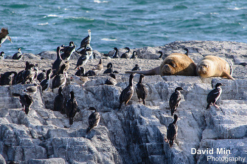
Ushuaia, at the southern extreme of Patagonia, offers tourist resources that are quite unique in the world.
A land of legends that many audacious spirits in the world have dreamt of visiting, and a land rather barren, inhabited only by those who have accepted the challenge of loneliness, their only company being nature at its best! Located on the shores of the Beagle Channel, Ushuaia is the southernmost city in the world. The city of Ushuaia is the capital of the Tierra del Fuego, Antarctica and Islands of the South Atlantic Province.
It was founded on October 12, 1884, and the meaning of its name in Yámana language is "bay that penetrates towards the west."
It is surrounded by the mountain range Martial that offers a unique combination of mountains, sea, glaciers, lakes and forests, overlooking the Beagle Canal, in the South end of the continent. There you are only 625 miles away of the Antarctic peninsula and 1900 Miles south from the city of Buenos Aires.
Catamaran trips will take you around the Beagle channel and give you nice views of the mountains, cormorants, sea lions and penguins.
Wednesday, March 13, 2013
El Chalten, Argentina - Sunrise over Mounts Fitz Roy & Cerro Torre

El Chalten, Argentina - Sunrise over Mounts Fitz Roy & Cerro Torre, a photo by GlobeTrotter 2000 on Flickr.
Mount Fitz Roy (3 359 m) is a mountain located near El Chaltén village, in the Southern Patagonian Ice Field in Patagonia, on the border between Argentina and Chile. First climbed in 1952 by French alpinists Lionel Terray and Guido Magnone, it remains among the most technically challenging mountains on Earth for mountaineers. Monte Fitz Roy is the basis for the Patagonia clothing logo following Yvon Chouinard's ascent and subsequent film in 1968.
The mountain has a reputation of being "ultimate", despite its average height (although being the highest peak in the Los Glaciares park, it is less than half the size of the Himalayan giants), because the sheer granite faces present long stretches of arduous technical climbing. In addition, the weather in the area is exceptionally inclement and treacherous. It also attracts many photographers thanks to its otherworldly shape. The area, while still fairly inaccessible, was even more isolated until the recent development of El Chaltén village and El Calafate international airport. The mountain climb, however, remains extremely difficult and is the preserve of very experienced climbers. Today, when a hundred people may reach the summit of Mount Everest in a single day, Monte Fitz Roy may only be successfully ascended once a year.
Tuesday, March 12, 2013
Torres del Paine, Chile

Torres del Paine is a national park in the Extreme South region of Patagonian Chile. It is located in the southern tiers of the Andes and features mountains, lakes and glaciers.The Torres del Paine (Spanish for "Towers of Paine" and "Paine" is the old indigenos name for the colour blue), three immense rock towers give the park its name.
Other attractions include the Cuernos del Paine (Spanish for "Horns of Paine" -- horn-like mountain tops), Grey Glacier, Lago Grey, Lago Pehoe, Lago Nordenskjöld and Lago Sarmiento. Jutting out some 2800m above the Patagonian steppe, the Torres del Paine (Towers of Paine) are spectacular granite pillars that dominate the landscape of what may be South America's finest national park (admission high/low season US$17/8.50). These breathtaking spires are flanked by the summit of Paine Grande (3050m) and the sharp tusks of black sedimentary peaks known as Los Cuernos (The Horns; 2200m to 2600m). Yes, these are the famous Patagonian mountains that you see on posters and book covers all over the world.
But the park is not just mountains. Trails meander through emerald forests, alongside and over roaring rivers, past radiant blue glaciers, azure lakes and up to jaw-dropping lookouts. You can hike into the vast openness of the steppe, heading to less-visited lakes and glaciers, all the while keeping an eye on the looming peaks. That is when the weather is clear. Unpredictable at best, weather systems can sheath the peaks in veils of clouds that hold for hours, if not days. Even then, the park has its allure - but it is always wise to plan a few extra days to make sure that your trip isn't torpedoed by a spot of bad weather.
Monday, March 11, 2013
El Calafate, Argentina - Perito Moreno Glacier
The Perito Moreno Glacier is a glacier located in the Los Glaciares National Park in south west Santa Cruz province, Argentina. It is one of the most important tourist attractions in the Argentine Patagonia. The 250 km2 ice formation, and 30 km in length, is one of 48 glaciers fed by the Southern Patagonian Ice Field located in the Andes system shared with Chile. This icefield is the world's third largest reserve of fresh water.
The Perito Moreno glacier, located 78 kilometres from El Calafate, was named after the explorer Francisco Moreno, a pioneer who studied the region in the 19th century and played a major role in defending the territory of Argentina in the conflict surrounding the international border dispute with Chile. The Perito Moreno Glacier is one of only three Patagonian glaciers that is growing. The reason remains debated by glaciologists.The terminus of the Perito Moreno Glacier is 5 kilometres wide, with an average height of 74 m above the surface of the water of Lake Argentino, in Argentina. It has a total ice depth of 170 metres.
Pressures from the weight of the ice slowly pushes the glacier over the southern arm ("Brazo Rico") of "Lago Argentino" ("Lake Argentina") damming the section and separating it from the rest of the lake. With no outlet, the water-level on the "Brazo Rico" side of the lake can rise by as much as 30 meters above the level of the main body of Lake Argentina. Periodically, the pressure produced by the height of the dammed water breaks through the ice barrier causing a spectacular rupture, sending a massive outpouring of water from the Brazo Rico section to the main body of Lake Argentina.
Due to its size and accessibility, Perito Moreno is one of the major tourist attractions in southern Patagonia. It is less than two hours by bus from El Calafate, and many tour companies run daily visits. A large visitor centre at the site features a walking circuit which allows visitors to view the southern flank and the east facing edge of the glacier.
In recent years, trekking tours on the ice have gained popularity. The two standard tours are a "mini-trekking" option, consisting of a short walk of about an hour and a half, and a "big ice" version, which is usually about five hours. Tour companies generally provide crampons to customers.
Sunday, March 10, 2013
El Chalten, Argentina - Mount Fitz Roy
Mount Fitz Roy (3 359 m) is a mountain located near El Chaltén village, in the Southern Patagonian Ice Field in Patagonia, on the border between Argentina and Chile. First climbed in 1952 by French alpinists Lionel Terray and Guido Magnone, it remains among the most technically challenging mountains on Earth for mountaineers. Monte Fitz Roy is the basis for the Patagonia clothing logo following Yvon Chouinard's ascent and subsequent film in 1968.
The mountain has a reputation of being "ultimate", despite its average height (although being the highest peak in the Los Glaciares park, it is less than half the size of the Himalayan giants), because the sheer granite faces present long stretches of arduous technical climbing. In addition, the weather in the area is exceptionally inclement and treacherous. It also attracts many photographers thanks to its otherworldly shape. The area, while still fairly inaccessible, was even more isolated until the recent development of El Chaltén village and El Calafate international airport. The mountain climb, however, remains extremely difficult and is the preserve of very experienced climbers. Today, when a hundred people may reach the summit of Mount Everest in a single day,[7] Monte Fitz Roy may only be successfully ascended once a year.
Wednesday, March 6, 2013
Ushuaia, Argentina - Laguna Esmeralda
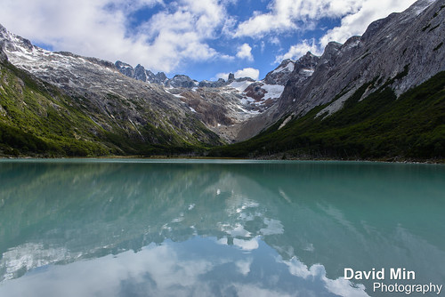
The half-day walk up to Laguna Esmeralda, 15km back up toward Paso Garibaldi, was a second easy way to discover the area around Ushuaia.
Well worth the effort to see - a beautiful lake surrounded by snow capped mountains with superb riverine scenery en route. You could sit for hours watching the lake and its surroundings as the sky changes with varying weather conditions.
Monday, March 4, 2013
Ushuaia, Argentina - Fin Del Mundo
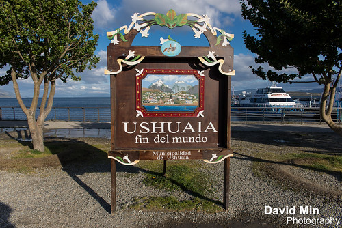
Situated on the Beagle Strait, Ushuaia is the largest city in Argentine Tierra del Fuego, and arguably the southernmost city in the world. In the past, the town has been a missionary base, penal colony and naval base for the Argentine navy. Ushuaia is now a major tourist town, complete with casinos and nice restaurants, and commonly used as a base for hiking, winter sports and cruises to Antarctica.
Today the town is growing fast as a result of increased tourism since the 2002 economic crash. The government has encouraged this growth by designating Tierra del Fuego a virtually tax-free zone to encourage people to settle (many of the inhabitants of today's Ushuaia come from Chaco, in the north of Argentina). The cost of living however, is relatively high as all goods have to be transported long distances, usually by container ship.
Thursday, February 14, 2013
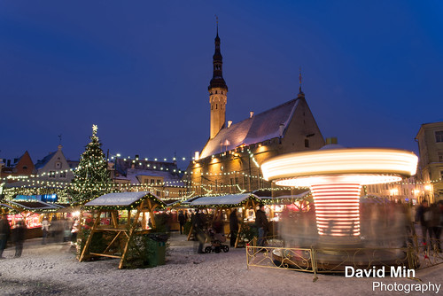
Tallinn, Estonia - Christmas Tree

The small and enchanting cobbled streets of Tallinn are brought to life during the winter period with a light dusting of snow on rooftops and pavements.
On the north-eastern edge of the Baltic Sea, Tallinn, the capital of Estonia, is one of the best preserved medieval towns in Europe, and as such the old town area is included in Unesco's world heritage list. The aura of the 14th and 15th centuries survives intact in Tallinn's old town, through its jumble of medieval walls and turrets, needling spires and winding cobbled streets. The city can be easily explored on foot, which is the best way to see the historic old town and absorb the atmosphere and bright activity of its bustling squares.
Like other Baltic capitals, Tallinn's main square is the center of celebrations for New Year's Eve. Private parties, concerts, and balls are hosted by restaurants, hotels, clubs, and other venues to ring in the new year. If you plan to stick out the evening in Tallinn's squares, dress warmly - the Estonian capital is cold in December!
Sunday, February 10, 2013
Siem Reap - Monk at Angkor

Dating from the 12th century, Bayon Temple is the spectacular central temple of the ancient city of Angkor Thom. The complex is located just to the north of the famous Angkor Wat.
Angkor Thom was built as a square, the sides of which run exactly north to south and east to west. Standing in the exact center of the walled city, Bayon Temple represents the intersection of heaven and earth.
Bayon is known for its huge stone faces of the bodhisattva Avalokiteshvara, with one facing outward and keeping watch at each compass point. The curious smiling image, thought by many to be a portrait of Jayavarman himself, has been dubbed by some the "Mona Lisa of Southeast Asia." There are 51 smaller towers surrounding Bayon, each with four faces of its own.
Thursday, February 7, 2013
Kompong Thom, Cambodia - Little Girl @Dailylife

Kompong Thom is the capital of Kampong Thom Province in Cambodia. It's situated about half-way between Phnom Penh and Siem Reap and thus most travellers will only rush through on their transfer between these two major attractions.
Nevertheless it is a pleasant and relaxed place and a good starting point for exploring the countryside and the temples of Sambor Prei Kuk.
There is an interesting fruit bat roost in the grounds of the old governors residence (a nice colonial era building). This is behind the market on the first road off the river. If the gate to the old governors building is open, you may be in luck, the house itself is sometimes left unlocked. All of the original furnishings are missing, but some of the bathroom fixtures remain and the house itself gives off a haunted vibe.
The grasslands and rice-fields surrounding Kompong Thom of an extreme importance for wildlife conservation. These areas hold the largest global population of the endangered Bustard the Bengal Florican as well as occasional large waterbirds from the Tonle Sap floodplain (Adjutants, Pelican, Painted Stork). Other species include large numbers of wintering palearctic passerines (including Dusky Warbler, Yellow-breasted Bunting, Siberian Rubythroat) and the globally vulnerable Manchurian Reed Warbler. In March large numbers of Oriental Plover pass through the area making this possibly the best area in the world to see this species.
The areas also offer a glimpse of everyday life in the Cambodian countryside with many fishermen, ox-carts and small scale farmers. The best way to visit the grasslands is by en-listing the help of a moto-dop driver from in-front of the Arunras guesthouse. A number of these know the area (around Rolous village about 5km towards Phnom Penh) and speak English.
Friday, February 1, 2013
Bank of China, Central Hong Kong

The Bank of China Tower is one of the most recognized skyscrapers in Central, Hong Kong. It houses the headquarters for the Bank of China (Hong Kong) Limited.
If Hong Kong is a city of jade during the day, it becomes a luminous pearl with a sea of lights twinkling in the streets after dark. Where is the best place to enjoy the multi-colorful night scene that encompasses Hong Kong and Victoria Harbor? Victoria Peak is a good location to view its night scene. Being 554 meters above sea level, Victoria Peak is the highest point within Hong Kong and occupies the western part of the island.
Viewing Hong Kong at night is a must! The panoramic vista is one of the most beautiful night scenes in the world so a visit to the Lion Pavilion on the peak is a must. Standing upon the pavilion and overlooking the Victoria Harbor and the Kowloon Peninsula, a spectacular night view will unfold in front of your eyes. The Victoria Harbor is one of the world's busiest harbors and has a constant ebb and flow of shipping all year round. With row upon row of skyscrapers stand prominently on the Central District which is Hong Kong's financial and economic hub. The most spectacular are the Bank of China Tower and the Central Plaza. The Bank of China Tower, with 72 stories soars skyward and is designed by an American-born Chinese architect Ieoh Ming Pei; with the bamboo-shaped outlook of the tower symbolizing that the Bank of China aspires to get better and better.
Wednesday, January 30, 2013
Helsinki, Finland - Frozen Sea
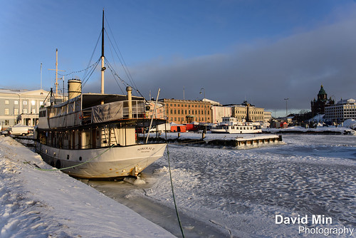
Helsinki is the capital of Finland. Founded in 1550, the "Daughter of the Baltic" has been the Finnish capital since 1812, when it was rebuilt by the tsars of Russia along the lines of a miniature St. Petersburg, a role it has played in many a Cold War movie.
Sunday, January 27, 2013
Tallinn, Estonia - Christmas Tree
The small and enchanting cobbled streets of Tallinn are brought to life during the winter period with a light dusting of snow on rooftops and pavements.
On the north-eastern edge of the Baltic Sea, Tallinn, the capital of Estonia, is one of the best preserved medieval towns in Europe, and as such the old town area is included in Unesco's world heritage list. The aura of the 14th and 15th centuries survives intact in Tallinn's old town, through its jumble of medieval walls and turrets, needling spires and winding cobbled streets. The city can be easily explored on foot, which is the best way to see the historic old town and absorb the atmosphere and bright activity of its bustling squares.
Like other Baltic capitals, Tallinn's main square is the center of celebrations for New Year's Eve. Private parties, concerts, and balls are hosted by restaurants, hotels, clubs, and other venues to ring in the new year. If you plan to stick out the evening in Tallinn's squares, dress warmly - the Estonian capital is cold in December!
Sunday, January 20, 2013
Tallinn, Estonia - Old Street

The small and enchanting cobbled streets of Tallinn are brought to life during the winter period with a light dusting of snow on rooftops and pavements.
On the north-eastern edge of the Baltic Sea, Tallinn, the capital of Estonia, is one of the best preserved medieval towns in Europe, and as such the old town area is included in Unesco's world heritage list. The aura of the 14th and 15th centuries survives intact in Tallinn's old town, through its jumble of medieval walls and turrets, needling spires and winding cobbled streets. The city can be easily explored on foot, which is the best way to see the historic old town and absorb the atmosphere and bright activity of its bustling squares.
Like other Baltic capitals, Tallinn's main square is the center of celebrations for New Year's Eve. Private parties, concerts, and balls are hosted by restaurants, hotels, clubs, and other venues to ring in the new year. If you plan to stick out the evening in Tallinn's squares, dress warmly - the Estonian capital is cold in December!
Thursday, January 17, 2013
Ngorongoro Crater, Tanzania

The Ngorongoro Conservation Area is a conservation area and a UNESCO World Heritage Site situated 180 km west of Arusha in the Crater Highlands area of Tanzania. The Ngorongoro Crater, a large volcanic caldera, lies within the area.
A population of approximately 25,000 large animals, largely ungulates along with reputedly the highest density of mammalian predators in Africa, lives in the crater. Large animals in the crater include the black rhinoceros, the local population of which declined from about 108 in 1964-66 to between 11-14 in 1995, and the hippopotamus, which is very uncommon in the area. There also are many other ungulates: the wildebeest (7,000 estimated in 1994), the zebra (4,000), the eland, and Grant's and Thompson's gazelles (3,000).
The crater has the densest known population of lions, numbering 62 in 2001. On the crater rim are leopards, elephants – numbering 42 in 1987 but only 29 in 1992 – mountain reedbuck, and buffalo (4,000 in 1994). In the middle of the crater there is a large lake inhabited by hundreds of flamingoes and from a distance, they appear as a pink border of the lake.
Aside from herds of zebra, gazelle, and wildebeest, the crater is home to the "big five" of rhinoceros, lion, leopard, elephant, and buffalo. The crater plays host to almost every individual species of wildlife in East Africa, with an estimated 25 000 animals within the crater.
Thursday, January 10, 2013
Helsinki, Finland - I Wanna Be A Star ;)
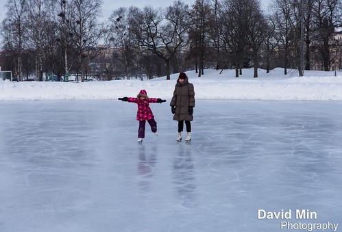
Helsinki is the capital of Finland. Founded in 1550, the "Daughter of the Baltic" has been the Finnish capital since 1812, when it was rebuilt by the tsars of Russia along the lines of a miniature St. Petersburg, a role it has played in many a Cold War movie. Today, Helsinki pulls off the trick of being something of an international metropolis while still retaining a small-town feel. The best time to visit is in summer, when Finns peel off their overcoats and flock to outdoor bars and cafes to enjoy the sunshine.
Sunday, January 6, 2013
Tallinn, Estonia - Christmas Tree

The small and enchanting cobbled streets of Tallinn are brought to life during the winter period with a light dusting of snow on rooftops and pavements.
On the north-eastern edge of the Baltic Sea, Tallinn, the capital of Estonia, is one of the best preserved medieval towns in Europe, and as such the old town area is included in Unesco's world heritage list. The aura of the 14th and 15th centuries survives intact in Tallinn's old town, through its jumble of medieval walls and turrets, needling spires and winding cobbled streets. The city can be easily explored on foot, which is the best way to see the historic old town and absorb the atmosphere and bright activity of its bustling squares.
Like other Baltic capitals, Tallinn's main square is the center of celebrations for New Year's Eve. Private parties, concerts, and balls are hosted by restaurants, hotels, clubs, and other venues to ring in the new year. If you plan to stick out the evening in Tallinn's squares, dress warmly - the Estonian capital is cold in December!
Subscribe to:
Posts (Atom)