Torres del Paine is a national park in the Extreme South region of Patagonian Chile. It is located in the southern tiers of the Andes and features mountains, lakes and glaciers.
The Torres del Paine (Spanish for "Towers of Paine" and "Paine" is the old indigenos name for the colour blue), three immense rock towers give the park its name.
Other attractions include the Cuernos del Paine (Spanish for "Horns of Paine" -- horn-like mountain tops), Grey Glacier, Lago Grey, Lago Pehoe, Lago Nordenskjöld and Lago Sarmiento. Jutting out some 2800m above the Patagonian steppe, the Torres del Paine (Towers of Paine) are spectacular granite pillars that dominate the landscape of what may be South America's finest national park (admission high/low season US$17/8.50). These breathtaking spires are flanked by the summit of Paine Grande (3050m) and the sharp tusks of black sedimentary peaks known as Los Cuernos (The Horns; 2200m to 2600m). Yes, these are the famous Patagonian mountains that you see on posters and book covers all over the world.
But the park is not just mountains. Trails meander through emerald forests, alongside and over roaring rivers, past radiant blue glaciers, azure lakes and up to jaw-dropping lookouts. You can hike into the vast openness of the steppe, heading to less-visited lakes and glaciers, all the while keeping an eye on the looming peaks. That is when the weather is clear. Unpredictable at best, weather systems can sheath the peaks in veils of clouds that hold for hours, if not days. Even then, the park has its allure - but it is always wise to plan a few extra days to make sure that your trip isn't torpedoed by a spot of bad weather.
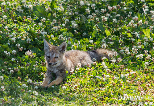
Thursday, March 28, 2013
Torres del Paine, Chile - Fox
Sunday, March 24, 2013
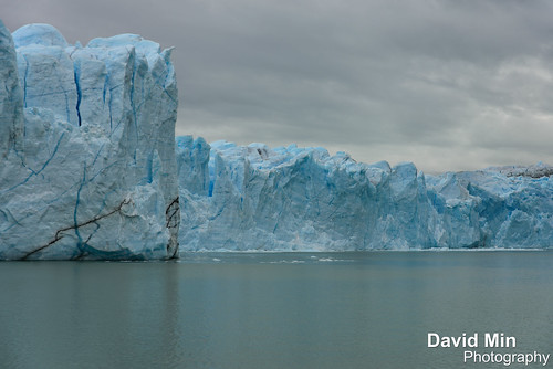
El Calafate, Argentina - Perito Moreno Glacier

To give you an idea, the explosion is as high as the first floor of the Eiffel Tower !
The Perito Moreno Glacier is a glacier located in the Los Glaciares National Park in south west Santa Cruz province, Argentina. It is one of the most important tourist attractions in the Argentine Patagonia. The 250 km2 ice formation, and 30 km in length, is one of 48 glaciers fed by the Southern Patagonian Ice Field located in the Andes system shared with Chile. This icefield is the world's third largest reserve of fresh water.
The Perito Moreno glacier, located 78 kilometres from El Calafate, was named after the explorer Francisco Moreno, a pioneer who studied the region in the 19th century and played a major role in defending the territory of Argentina in the conflict surrounding the international border dispute with Chile. The Perito Moreno Glacier is one of only three Patagonian glaciers that is growing. The reason remains debated by glaciologists.The terminus of the Perito Moreno Glacier is 5 kilometres wide, with an average height of 74 m above the surface of the water of Lake Argentino, in Argentina. It has a total ice depth of 170 metres.
Pressures from the weight of the ice slowly pushes the glacier over the southern arm ("Brazo Rico") of "Lago Argentino" ("Lake Argentina") damming the section and separating it from the rest of the lake. With no outlet, the water-level on the "Brazo Rico" side of the lake can rise by as much as 30 meters above the level of the main body of Lake Argentina. Periodically, the pressure produced by the height of the dammed water breaks through the ice barrier causing a spectacular rupture, sending a massive outpouring of water from the Brazo Rico section to the main body of Lake Argentina.
Due to its size and accessibility, Perito Moreno is one of the major tourist attractions in southern Patagonia. It is less than two hours by bus from El Calafate, and many tour companies run daily visits. A large visitor centre at the site features a walking circuit which allows visitors to view the southern flank and the east facing edge of the glacier.
In recent years, trekking tours on the ice have gained popularity. The two standard tours are a "mini-trekking" option, consisting of a short walk of about an hour and a half, and a "big ice" version, which is usually about five hours. Tour companies generally provide crampons to customers.
Friday, March 22, 2013
El Calafate, Argentina - Perito Moreno Explosion
El Calafate, Argentina - Perito Moreno Explosion a video by GlobeTrotter 2000 on Flickr.
The Perito Moreno Glacier is a glacier located in the Los Glaciares National Park in south west Santa Cruz province, Argentina. It is one of the most important tourist attractions in the Argentine Patagonia. The 250 km2 ice formation, and 30 km in length, is one of 48 glaciers fed by the Southern Patagonian Ice Field located in the Andes system shared with Chile. This icefield is the world's third largest reserve of fresh water.
The Perito Moreno glacier, located 78 kilometres from El Calafate, was named after the explorer Francisco Moreno, a pioneer who studied the region in the 19th century and played a major role in defending the territory of Argentina in the conflict surrounding the international border dispute with Chile. The Perito Moreno Glacier is one of only three Patagonian glaciers that is growing. The reason remains debated by glaciologists.The terminus of the Perito Moreno Glacier is 5 kilometres wide, with an average height of 74 m above the surface of the water of Lake Argentino, in Argentina. It has a total ice depth of 170 metres.
Pressures from the weight of the ice slowly pushes the glacier over the southern arm ("Brazo Rico") of "Lago Argentino" ("Lake Argentina") damming the section and separating it from the rest of the lake. With no outlet, the water-level on the "Brazo Rico" side of the lake can rise by as much as 30 meters above the level of the main body of Lake Argentina. Periodically, the pressure produced by the height of the dammed water breaks through the ice barrier causing a spectacular rupture, sending a massive outpouring of water from the Brazo Rico section to the main body of Lake Argentina.
Due to its size and accessibility, Perito Moreno is one of the major tourist attractions in southern Patagonia. It is less than two hours by bus from El Calafate, and many tour companies run daily visits. A large visitor centre at the site features a walking circuit which allows visitors to view the southern flank and the east facing edge of the glacier.
In recent years, trekking tours on the ice have gained popularity. The two standard tours are a "mini-trekking" option, consisting of a short walk of about an hour and a half, and a "big ice" version, which is usually about five hours. Tour companies generally provide crampons to customers.
Thursday, March 21, 2013
Torres Del Paine, Chile - Guanaco

The guanaco is a vulnerable animal native to the arid, mountainous regions of South America. Guanaco are found in the altiplano of Peru, Bolivia, Ecuador, Colombia, Chile and Argentina. In Argentina, they are more numerous in Patagonian regions, in places like the Torres del Paine National Park, and Isla Grande de Tierra del Fuego. In these areas, they have more robust populations, since there are limitations on grazing competition from livestock.
Torres del Paine is a national park in the Extreme South region of Patagonian Chile. It is located in the southern tiers of the Andes and features mountains, lakes and glaciers.
The Torres del Paine (Spanish for "Towers of Paine" and "Paine" is the old indigenos name for the colour blue), three immense rock towers give the park its name.
Other attractions include the Cuernos del Paine (Spanish for "Horns of Paine" -- horn-like mountain tops), Grey Glacier, Lago Grey, Lago Pehoe, Lago Nordenskjöld and Lago Sarmiento. Jutting out some 2800m above the Patagonian steppe, the Torres del Paine (Towers of Paine) are spectacular granite pillars that dominate the landscape of what may be South America's finest national park (admission high/low season US$17/8.50). These breathtaking spires are flanked by the summit of Paine Grande (3050m) and the sharp tusks of black sedimentary peaks known as Los Cuernos (The Horns; 2200m to 2600m). Yes, these are the famous Patagonian mountains that you see on posters and book covers all over the world.
Tuesday, March 19, 2013
Torres Del Paine, Chile - Fire In The Sky Over My Estancia
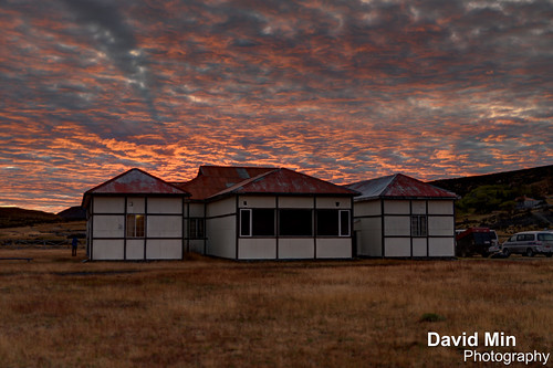
Estancia is a Spanish and Brazilian Portuguese term describing a large rural estate with similarities to the English term ranch. The term is used in Argentina, Uruguay, southern Chile and southern Brazil. The equivalent in other Latin American countries would be hacienda.
Unlike a hacienda, which could be any type of agricultural venture, producing grain, coffee, vegetable, beef, etc., an estancia, most typically located in the southern South American grasslands, the pampas, has historically always been a livestock (cattle or sheep) estate.
Torres del Paine is a national park in the Extreme South region of Patagonian Chile. It is located in the southern tiers of the Andes and features mountains, lakes and glaciers.
The Torres del Paine (Spanish for "Towers of Paine" and "Paine" is the old indigenos name for the colour blue), three immense rock towers give the park its name.
Other attractions include the Cuernos del Paine (Spanish for "Horns of Paine" -- horn-like mountain tops), Grey Glacier, Lago Grey, Lago Pehoe, Lago Nordenskjöld and Lago Sarmiento. Jutting out some 2800m above the Patagonian steppe, the Torres del Paine (Towers of Paine) are spectacular granite pillars that dominate the landscape of what may be South America's finest national park (admission high/low season US$17/8.50). These breathtaking spires are flanked by the summit of Paine Grande (3050m) and the sharp tusks of black sedimentary peaks known as Los Cuernos (The Horns; 2200m to 2600m). Yes, these are the famous Patagonian mountains that you see on posters and book covers all over the world.
But the park is not just mountains. Trails meander through emerald forests, alongside and over roaring rivers, past radiant blue glaciers, azure lakes and up to jaw-dropping lookouts. You can hike into the vast openness of the steppe, heading to less-visited lakes and glaciers, all the while keeping an eye on the looming peaks. That is when the weather is clear. Unpredictable at best, weather systems can sheath the peaks in veils of clouds that hold for hours, if not days. Even then, the park has its allure - but it is always wise to plan a few extra days to make sure that your trip isn't torpedoed by a spot of bad weather.
Sunday, March 17, 2013
El Chalten, Argentina - Marvelous Fitz Roy

Hikers who visit Torres del Paine in Chile are urged to hike nearby Fitz Roy. A similar fantastical landscape — but with even worse weather ! I was so lucky that day :)
- Paine & Fitz Roy are the best two hikes in Patagonia
- the jagged mountains of Paine are surreal - but I feel Fitz Roy is even more stunning
- the biggest concern for hikers is wind. It can blow steady from November to April. We have never seen wind like this anywhere else in the world...
Mount Fitz Roy (3 359 m) is a mountain located near El Chaltén village, in the Southern Patagonian Ice Field in Patagonia, on the border between Argentina and Chile. First climbed in 1952 by French alpinists Lionel Terray and Guido Magnone, it remains among the most technically challenging mountains on Earth for mountaineers. Monte Fitz Roy is the basis for the Patagonia clothing logo following Yvon Chouinard's ascent and subsequent film in 1968.
The mountain has a reputation of being "ultimate", despite its average height (although being the highest peak in the Los Glaciares park, it is less than half the size of the Himalayan giants), because the sheer granite faces present long stretches of arduous technical climbing. In addition, the weather in the area is exceptionally inclement and treacherous. It also attracts many photographers thanks to its otherworldly shape. The area, while still fairly inaccessible, was even more isolated until the recent development of El Chaltén village and El Calafate international airport. The mountain climb, however, remains extremely difficult and is the preserve of very experienced climbers. Today, when a hundred people may reach the summit of Mount Everest in a single day, Monte Fitz Roy may only be successfully ascended once a year.
Saturday, March 16, 2013
Ushuaia, Argentina - Sea Lions & Cormorants
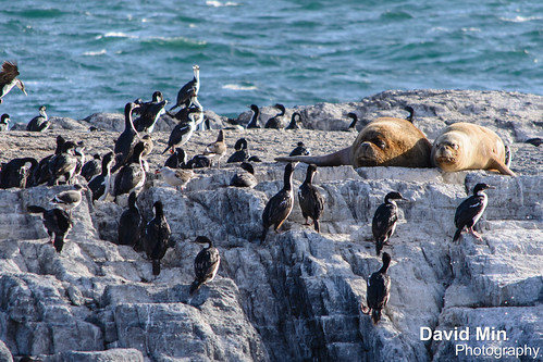
Ushuaia, at the southern extreme of Patagonia, offers tourist resources that are quite unique in the world.
A land of legends that many audacious spirits in the world have dreamt of visiting, and a land rather barren, inhabited only by those who have accepted the challenge of loneliness, their only company being nature at its best! Located on the shores of the Beagle Channel, Ushuaia is the southernmost city in the world. The city of Ushuaia is the capital of the Tierra del Fuego, Antarctica and Islands of the South Atlantic Province.
It was founded on October 12, 1884, and the meaning of its name in Yámana language is "bay that penetrates towards the west."
It is surrounded by the mountain range Martial that offers a unique combination of mountains, sea, glaciers, lakes and forests, overlooking the Beagle Canal, in the South end of the continent. There you are only 625 miles away of the Antarctic peninsula and 1900 Miles south from the city of Buenos Aires.
Catamaran trips will take you around the Beagle channel and give you nice views of the mountains, cormorants, sea lions and penguins.
Wednesday, March 13, 2013
El Chalten, Argentina - Sunrise over Mounts Fitz Roy & Cerro Torre

El Chalten, Argentina - Sunrise over Mounts Fitz Roy & Cerro Torre, a photo by GlobeTrotter 2000 on Flickr.
Mount Fitz Roy (3 359 m) is a mountain located near El Chaltén village, in the Southern Patagonian Ice Field in Patagonia, on the border between Argentina and Chile. First climbed in 1952 by French alpinists Lionel Terray and Guido Magnone, it remains among the most technically challenging mountains on Earth for mountaineers. Monte Fitz Roy is the basis for the Patagonia clothing logo following Yvon Chouinard's ascent and subsequent film in 1968.
The mountain has a reputation of being "ultimate", despite its average height (although being the highest peak in the Los Glaciares park, it is less than half the size of the Himalayan giants), because the sheer granite faces present long stretches of arduous technical climbing. In addition, the weather in the area is exceptionally inclement and treacherous. It also attracts many photographers thanks to its otherworldly shape. The area, while still fairly inaccessible, was even more isolated until the recent development of El Chaltén village and El Calafate international airport. The mountain climb, however, remains extremely difficult and is the preserve of very experienced climbers. Today, when a hundred people may reach the summit of Mount Everest in a single day, Monte Fitz Roy may only be successfully ascended once a year.
Tuesday, March 12, 2013
Torres del Paine, Chile

Torres del Paine is a national park in the Extreme South region of Patagonian Chile. It is located in the southern tiers of the Andes and features mountains, lakes and glaciers.The Torres del Paine (Spanish for "Towers of Paine" and "Paine" is the old indigenos name for the colour blue), three immense rock towers give the park its name.
Other attractions include the Cuernos del Paine (Spanish for "Horns of Paine" -- horn-like mountain tops), Grey Glacier, Lago Grey, Lago Pehoe, Lago Nordenskjöld and Lago Sarmiento. Jutting out some 2800m above the Patagonian steppe, the Torres del Paine (Towers of Paine) are spectacular granite pillars that dominate the landscape of what may be South America's finest national park (admission high/low season US$17/8.50). These breathtaking spires are flanked by the summit of Paine Grande (3050m) and the sharp tusks of black sedimentary peaks known as Los Cuernos (The Horns; 2200m to 2600m). Yes, these are the famous Patagonian mountains that you see on posters and book covers all over the world.
But the park is not just mountains. Trails meander through emerald forests, alongside and over roaring rivers, past radiant blue glaciers, azure lakes and up to jaw-dropping lookouts. You can hike into the vast openness of the steppe, heading to less-visited lakes and glaciers, all the while keeping an eye on the looming peaks. That is when the weather is clear. Unpredictable at best, weather systems can sheath the peaks in veils of clouds that hold for hours, if not days. Even then, the park has its allure - but it is always wise to plan a few extra days to make sure that your trip isn't torpedoed by a spot of bad weather.
Monday, March 11, 2013
El Calafate, Argentina - Perito Moreno Glacier
The Perito Moreno Glacier is a glacier located in the Los Glaciares National Park in south west Santa Cruz province, Argentina. It is one of the most important tourist attractions in the Argentine Patagonia. The 250 km2 ice formation, and 30 km in length, is one of 48 glaciers fed by the Southern Patagonian Ice Field located in the Andes system shared with Chile. This icefield is the world's third largest reserve of fresh water.
The Perito Moreno glacier, located 78 kilometres from El Calafate, was named after the explorer Francisco Moreno, a pioneer who studied the region in the 19th century and played a major role in defending the territory of Argentina in the conflict surrounding the international border dispute with Chile. The Perito Moreno Glacier is one of only three Patagonian glaciers that is growing. The reason remains debated by glaciologists.The terminus of the Perito Moreno Glacier is 5 kilometres wide, with an average height of 74 m above the surface of the water of Lake Argentino, in Argentina. It has a total ice depth of 170 metres.
Pressures from the weight of the ice slowly pushes the glacier over the southern arm ("Brazo Rico") of "Lago Argentino" ("Lake Argentina") damming the section and separating it from the rest of the lake. With no outlet, the water-level on the "Brazo Rico" side of the lake can rise by as much as 30 meters above the level of the main body of Lake Argentina. Periodically, the pressure produced by the height of the dammed water breaks through the ice barrier causing a spectacular rupture, sending a massive outpouring of water from the Brazo Rico section to the main body of Lake Argentina.
Due to its size and accessibility, Perito Moreno is one of the major tourist attractions in southern Patagonia. It is less than two hours by bus from El Calafate, and many tour companies run daily visits. A large visitor centre at the site features a walking circuit which allows visitors to view the southern flank and the east facing edge of the glacier.
In recent years, trekking tours on the ice have gained popularity. The two standard tours are a "mini-trekking" option, consisting of a short walk of about an hour and a half, and a "big ice" version, which is usually about five hours. Tour companies generally provide crampons to customers.
Sunday, March 10, 2013
El Chalten, Argentina - Mount Fitz Roy
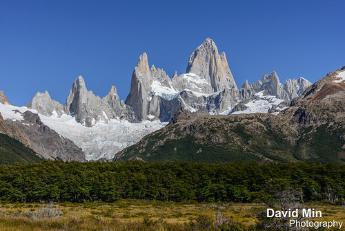
Mount Fitz Roy (3 359 m) is a mountain located near El Chaltén village, in the Southern Patagonian Ice Field in Patagonia, on the border between Argentina and Chile. First climbed in 1952 by French alpinists Lionel Terray and Guido Magnone, it remains among the most technically challenging mountains on Earth for mountaineers. Monte Fitz Roy is the basis for the Patagonia clothing logo following Yvon Chouinard's ascent and subsequent film in 1968.
The mountain has a reputation of being "ultimate", despite its average height (although being the highest peak in the Los Glaciares park, it is less than half the size of the Himalayan giants), because the sheer granite faces present long stretches of arduous technical climbing. In addition, the weather in the area is exceptionally inclement and treacherous. It also attracts many photographers thanks to its otherworldly shape. The area, while still fairly inaccessible, was even more isolated until the recent development of El Chaltén village and El Calafate international airport. The mountain climb, however, remains extremely difficult and is the preserve of very experienced climbers. Today, when a hundred people may reach the summit of Mount Everest in a single day,[7] Monte Fitz Roy may only be successfully ascended once a year.
Wednesday, March 6, 2013
Ushuaia, Argentina - Laguna Esmeralda
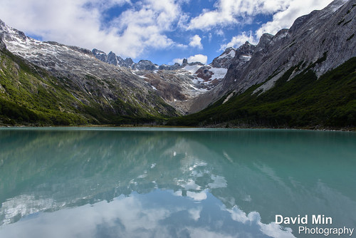
The half-day walk up to Laguna Esmeralda, 15km back up toward Paso Garibaldi, was a second easy way to discover the area around Ushuaia.
Well worth the effort to see - a beautiful lake surrounded by snow capped mountains with superb riverine scenery en route. You could sit for hours watching the lake and its surroundings as the sky changes with varying weather conditions.
Monday, March 4, 2013
Ushuaia, Argentina - Fin Del Mundo
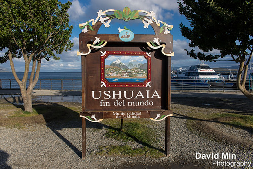
Situated on the Beagle Strait, Ushuaia is the largest city in Argentine Tierra del Fuego, and arguably the southernmost city in the world. In the past, the town has been a missionary base, penal colony and naval base for the Argentine navy. Ushuaia is now a major tourist town, complete with casinos and nice restaurants, and commonly used as a base for hiking, winter sports and cruises to Antarctica.
Today the town is growing fast as a result of increased tourism since the 2002 economic crash. The government has encouraged this growth by designating Tierra del Fuego a virtually tax-free zone to encourage people to settle (many of the inhabitants of today's Ushuaia come from Chaco, in the north of Argentina). The cost of living however, is relatively high as all goods have to be transported long distances, usually by container ship.