
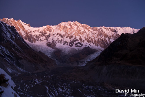
Annapurna III is a 24,787 ft / 7,555 m mountain peak in the Himalayas in Nepal. Based on peakery data, it ranks as the 20th highest mountain in Nepal. The nearest peaks are Gangapurna, Canharba Chuli, Tharpu Chuli, Machapuchhare, Tarke Kang, and Singu Chuli.
Annapurna III was first climbed in 1961 by an Indian expedition led by Capt. Mohan Singh Kohli, via the Northeast Face. The summit party comprised Mohan Kohli, Sonam Gyatso, and Sonam Girmi.
Monday, December 26, 2011
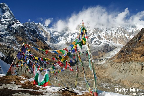
Annapurna III (7 555m), Nepal - Looking at the Immensity
Saturday, December 24, 2011

Monday, December 19, 2011
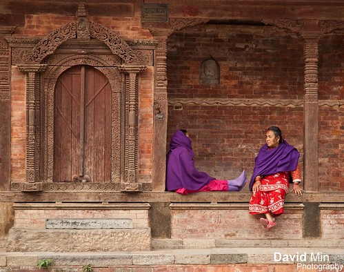
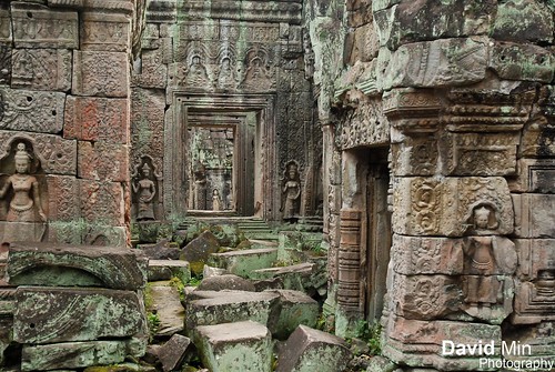
Kathmandu, Nepal - Monkey Temple
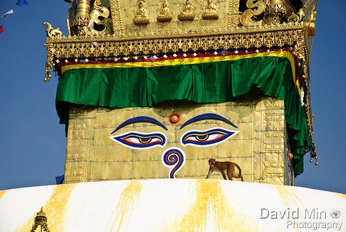
Swayambhunath is an ancient religious complex atop a hill in the Kathmandu Valley, west of Kathmandu city. It is also known as the Monkey Temple as there are holy monkeys living in parts of the temple in the north-west. The Tibetan name for the site means 'Sublime Trees', for the many varieties of trees found on the hill.
For the Buddhists, Swayambhunath occupies a central position, it is probably the most sacred among Buddhist pilgrimage sites. For Tibetans and followers of Tibetan Buddhism, it second only to Boudhanath.
The Swayambhunath complex consists of a stupa, a variety of shrines and temples, some dating back to the Licchavi period. A Tibetan monastery, museum and library are more recent additions. The stupa has Buddha's eyes and eyebrows painted on. Between them, there is something painted which looks like the nose - but is the Nepali symbol of 'unity', in the main Nepali language dialect.
Sunday, December 18, 2011
Annapurna I (8 091m) @Sunrise - 10th Highest Mountain in the World
Annapurna I (8 091m) @Sunrise - 10th Highest Mountain in the World, a photo by GlobeTrotter 2000 on Flickr.
Annapurna I (8 091m) - located in Nepal - is the most dangerous 8000-meter peak with an expedition fatality rate of 40%. In particular, the ascent via the south face is considered the most difficult of all climbs.
Annapurna I was the first 8,000-meter peak climbed and the first climbed without supplemental oxygen.
Maurice Herzon and Louis Lachenal, the first to summit Annapurna I in 1950, were part of a French team that included other great climbers including Gaston Rébuffat and Lionel Terray. Herzog and Lachenal both suffered severe frostbite on their feet and Herzog on his hands after losing his gloves. Gangrene set in afterward, forcing the expedition doctor to amputate fingers and toes in the field without anesthetic.
Maurice Herzog wrote the book Annapurna about the 1950 expedition, which has sold over 11 million copies, making it the best-selling climbing book of all time.
Friday, December 16, 2011
Kathmandu, Nepal - Durbar Square
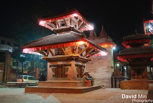
Durbar Square is the generic name used to describe plazas opposite old royal palaces in Nepal. Before the Unification of Nepal, Nepal consisted of small kingdoms, and Durbar Squares are most prominent remnants of those old kingdoms in Nepal. In particular, three Durbar Squares in the Kathmandu Valley, belonging to the three kingdoms situated there before unification, are most famous: Kathmandu Durbar Square, Patan Durbar Square, and Bhaktapur Durbar Square. All three are UNESCO World Heritage Sites.
The Kathmandu Durbar Square is surrounded by spectacular architecture and vividly showcases the skills of the Newari artists and craftsmen over several centuries. The royal palace was originally situated at Dattaraya square and was only later moved to the Durbar square location.
The Kathmandu Durbar Square holds the palaces of the Malla and Shah kings who ruled over the city. Along with these palaces, the square also surrounds quadrangles revealing courtyards and temples. The square is presently known as Hanuman Dhoka, a name derived from the statue of Hanuman, the monkey devotee of Lord Ram, near the entrance of the palace.
Monday, December 12, 2011
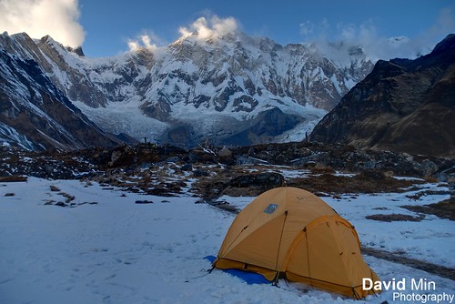
Annapurna Base Camp, Nepal - Frozen Morning
Annapurna is a section of the Himalayas in north-central Nepal that includes 8,091 metres (26,545 ft) Annapurna I, thirteen additional peaks over 7,000 m (22,970 ft) and 16 more over 6,000 m (19,690 ft).
The entire massif and surrounding area are protected within the 7,629 km2 Annapurna Conservation Area, the first and largest conservation area in Nepal. The Annapurna Conservation Area is home to several world-class treks, including the Annapurna Circuit.
The Annapurna peaks are the world's most dangerous mountains to climb although, from figures since 1990, Kangchenjunga surpasses Annapurna's death rate. As of 2007, there had been 153 summit ascents of Annapurna I, and 58 climbing fatalities on the mountain. This fatality to summit ratio (38%) is the highest of any of the eight-thousanders. In particular, the ascent via the south face is considered the most difficult of all climbs.
Sunday, December 11, 2011
Kathmandu, Nepal - Durbar Square
Durbar Square is the generic name used to describe plazas opposite old royal palaces in Nepal. Before the Unification of Nepal, Nepal consisted of small kingdoms, and Durbar Squares are most prominent remnants of those old kingdoms in Nepal. In particular, three Durbar Squares in the Kathmandu Valley, belonging to the three kingdoms situated there before unification, are most famous: Kathmandu Durbar Square, Patan Durbar Square, and Bhaktapur Durbar Square. All three are UNESCO World Heritage Sites.
The Kathmandu Durbar Square is surrounded by spectacular architecture and vividly showcases the skills of the Newari artists and craftsmen over several centuries. The royal palace was originally situated at Dattaraya square and was only later moved to the Durbar square location.
The Kathmandu Durbar Square holds the palaces of the Malla and Shah kings who ruled over the city. Along with these palaces, the square also surrounds quadrangles revealing courtyards and temples. The square is presently known as Hanuman Dhoka, a name derived from the statue of Hanuman, the monkey devotee of Lord Ram, near the entrance of the palace.
Saturday, December 3, 2011
Annapurna, Nepal - The Sanctuary
The Annapurna Sanctuary is “high glacial basin lying forty kilometers directly north of Pokhara. This oval-shaped plateau sits at an altitude of over 4000 meters, and is surrounded by a ring of mountains, the Annapurna range, most of which are over 7000 meters. With the only entrance a narrow pass between the peaks of Hiunchuli and Machapuchare, where run-off from glaciers drain into Modi Khola River, the Sanctuary was not penetrated by outsiders until 1956. Because of high mountains on all sides, the Annapurna Sanctuary receives only 7 hours of sunlight a day at the height of summer.
The unique combination of heights and depths in the Annapurna Sanctuary give rise to an extraordinary variety of ecosystems. The south-facing slope are “covered in dense tropical jungles of rhododendron and bamboo”, while the north-facing slopes, in the rain shadow, have “a drier colder climate similar to that of the near-by Tibetan Plateau.
The entire sanctuary was held as sacred to the Gurung people, one of the many native people to inhabit the area. They believed it was the repository of gold and various treasures left by the Nāgas, the serpent-gods known in India. The sanctuary was believed to be the home of several deities, from Hinduism and Buddhism as well the older animistic gods. The peak of Machapuchare at the entrance was believed to be the home of the god Shiva, and the daily plumes of snow were thought the smoke of his divine incense. Until recently, the local Gurang people forbade anyone from bringing eggs or meat into the Annapurna Sanctuary, and women and untouchables were prohibited from going there as well.
In recent years, the number of trekkers to the Sanctuary has increased substantially, in part because the Sanctuary forms the base of one of the major routes to the peaks of the Annapurna range. The Annapurna Sanctuary is now part of the Annapurna Conservation Area Project, which places restrictions on number of outside travelers, gathering of firewood, and domestic animal grazing.
Thanks to Earthbound Expeditions for having organized this expedition.
Sunday, November 6, 2011
Railay, Thailand - Hat Phra Nang Beach
Accessible by boat or a small pathway, this stunning, pristine beach has fine-grained white sand and crystalline waters as well as magnificent jagged karsts. This is a highly secluded picture perfect beach that attracts thousands of visitors year round but is able to maintain its flawless appearance and relaxing ambience.
This beach is the location of the 5-star Rayavadee resort, a private property that occupies 26 acres of the beach and the only compound located near Phra Nang Beach.
The Inner and Outer Phra Nang Caves, and Phra Nang Lagoon, which are located nearby offer remarkable views against a stunning backdrop and a range of accommodations to suit every budget. Although these attractions are accessible only by boat, they still draw numerous visitors for recreational and adventurous activities such as diving, snorkeling, hiking and rock climbing.
Saturday, October 22, 2011
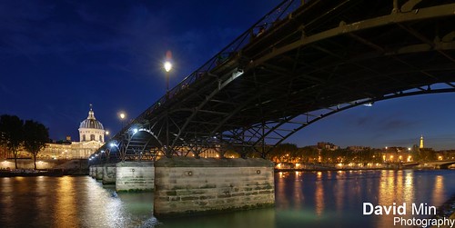
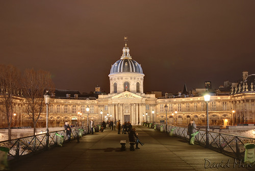
Paris, France - Couples @Ponts des Arts
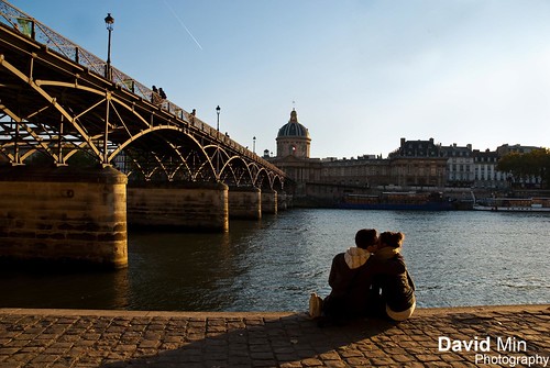
The Pont des Arts or Passerelle des Arts is a pedestrian bridge in Paris which crosses the Seine River. It links the Institut de France and the central square (cour carrée) of the palais du Louvre.
Between 1802 and 1804, a nine-arch metallic bridge for pedestrians was constructed at the location of the present day Pont des Arts: this was the first metal bridge in Paris. This innovation was due to Napoléon I, following a design of English manufacture.
The bridge has sometimes served as a place for art exhibitions, and is today a studio en plein air for painters, artists and photographers who are drawn to its unique point of view. The Pont des Arts is also frequently a spot for picnics during the summer.
Nowadays the bridge has become a hotspot for couples who attach a padlock to the railing and throw the key into the river below.
Saturday, October 8, 2011
Sunday, September 11, 2011
Tuesday, July 12, 2011
NYC, USA - United Nations Headquarters
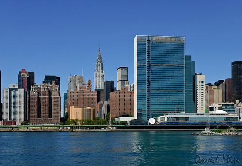
The United Nations Organization (UNO) or simply the United Nations (UN) is an international organization whose stated aims are facilitating cooperation in international law, international security, economic development, social progress, human rights, and achievement of world peace. The UN was founded in 1945 after World War II to replace the League of Nations, to stop wars between countries, and to provide a platform for dialogue. It contains multiple subsidiary organizations to carry out its missions.
The headquarters of the United Nations is a distinctive complex in New York City, United States, that has served as the official headquarters of the United Nations since its completion in 1952. It is located in the Turtle Bay neighborhood of Manhattan, on spacious grounds overlooking the East River. Its borders are First Avenue on the west, East 42nd Street to the south, East 48th Street on the north and the East River to the east.Turtle Bay is used as a synonym for the U.N. headquarters or for the U.N. as a whole.
Though it is in New York City, and part of the United States, the land used by the United Nations Headquarters is considered international territory, while also being subject to most local, state, and federal laws. For award purposes Amateur radio operators consider it a separate "entity", and for communications the UN has its own internationally recognized ITU prefix, 4U.
Saturday, June 18, 2011
Pont du Gard, France
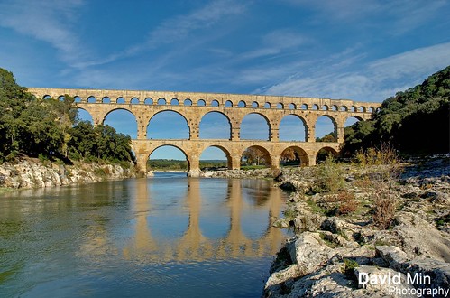
The Pont du Gard is a notable ancient Roman aqueduct bridge that crosses the Gard River in southern France. It is part of a 50 km long aqueduct that runs between Uzès and Nîmes in the South of France. The aqueduct was constructed by the Romans in the 1st century AD and was added to UNESCO's list of World Heritage Sites in 1985. It is the highest of all Roman aqueduct bridges and is the best preserved after the Aqueduct of Segovia.
The bridge has three rows of arches, standing 48.8 m high, and formerly carried an estimated 200 million litres of water a day to the fountains, baths and homes of the citizens of Nîmes. The aqueduct descends in height by only 17 m over its entire length, indicative of the great precision that Roman engineers were able to achieve using only simple technology. It was possibly used until as late as the 9th century, well after the fall of Rome. However, lack of maintenance after the 4th century meant that it became increasingly clogged by mineral deposits and debris that eventually choked off the flow of water.
The Pont du Gard's subsidiary function as a toll bridge ensured its survival in the Middle Ages. Although some of its stones were looted, the local lords and bishops were for centuries responsible for its upkeep in exchange for the right to levy tolls on travellers using it to cross the river. It attracted increasing fame from the 18th century onwards and became an important tourist destination. It underwent a series of renovations that culminated in 2000 with the opening of a new visitor centre and the removal of traffic and buildings from the bridge and the area immediately around it. Today it is one of France's most popular tourist attractions.
Sunday, June 5, 2011
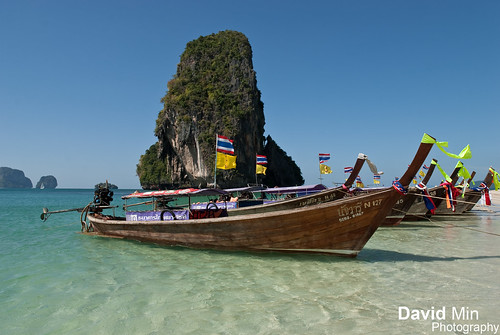
Railay Beach, Thailand - Tropical Paradise
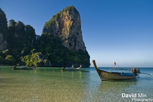
The coast in the south of Thailand is a luxurious tropical paradise. Towering limestone cliffs shelter incredible beaches, the most beautiful is Railay.
Isolated from the mainland, the peninsula of Railay is surrounded by the warm Andaman Sea, lush jungle, and twisted rock. It contains enough activities for the most adventurous while allowing those who just want to chill out in paradise the opportunity to do just that.
Tuesday, May 31, 2011
Paris La Defense, France - Psychedelic Lights
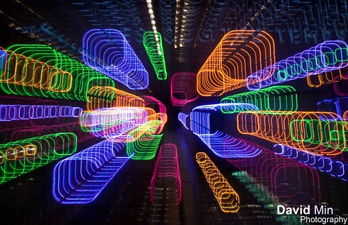
La Defense is a major business district for the city of Paris, bordering Neuilly-sur-Seine, west of the city itself. The district is at the westernmost extremity of Paris' 10 km long Historical Axis, which starts at the Louvre in Central Paris and continues along the Champs-Élysées, well beyond the Arc de Triomphe before culminating at La Defense.
Monday, May 9, 2011
Krabi, Thailand - Koh Poda and Koh Kai Islands

Koh Poda is a small limestone island 25 minutes by boat from the beaches of the Railey peninsula. The circular island is no more than a kilometre in diameter, covered in palm trees and almost entirely encircled by a soft white sand beach. A coral reef lies 20 metres offshore, and the combination of scenery, beach and excellent snorkelling make it one of my favourite places to spend a lazy day in this part of the world.
Chicken island or Koh Kai got its name from a bizarre rock formation which stands for the head of a chicken. One end of the island consists of steep cliffs, while the other end has beautiful beaches along a peninsula. This peninsula gets flooded at high tide, creating a small island.
Friday, May 6, 2011
Lijiang - Black Dragon Lake (China)

View of the Dragon Jade Mountain from the Black Dragon Lake.
Yunnan Province
Sunday, May 1, 2011
Sydney, Australia - Darling Harbour
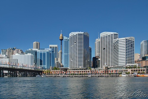
Darling Harbour is a locality of the city centre of Sydney, Australia. It is a large recreational and pedestrian precinct that is situated on western outskirts of the Sydney central business district. The locality extends northwards from Chinatown, along both sides of Cockle Bay to King Street Wharf on the east, and to the suburb of Pyrmont on the west. Cockle Bay is just one of the waterways that makes up Darling Harbour, which opens north into the much larger Port Jackson.
Thursday, April 28, 2011
Koh Phi Phi Leh, Thailand - Maya Bay
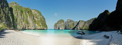
Maya Bay is a stunningly beautiful bay that's sheltered by 100-metre high cliffs on three sides. Inside the bay there are several beaches, most are small and some only exist at low tide. The main one is around 200 metres long with silky soft white sand, underwater colourful coral and exotic fish in exceptionally clear water; the whole bay is one big reef.
Maya Bay has become the main tourist attraction of Phi Phi since The Beach was filmed here in 1999. It was always very popular before the film but now people around the world who haven't even heard of Phi Phi have certainly heard of Maya Bay.
The bad news; as it's so beautiful and so well known many boats are required to ferry all the visitors in and out. On any given day at any time there will be 30 + speedboats and longtail boats on the beach, with large ferry boats carrying hundreds of snorkelers and sightseers moored in deeper water. Beautiful it is, secluded it isn't – thousands of people visit each day. Try to visit early in the morning or after 17:00 and you'll avoid the crowds.
Tuesday, April 26, 2011
Siem Reap, Cambodia - Angkor Wat
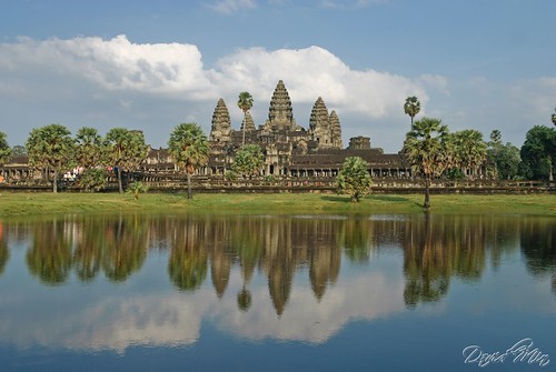
If you've read anything at all about Angkor Wat, you'll probably know at least three things: Angkor is one of the most beautiful and suggestive place on the planet, the Angkor Wat Temples area is much bigger than the Angkor Temple alone, and last, nothing is homogeneous, being the temples built in different times, during a four centuries process.
Many people, when they hear the name Angkor in a conversation, they ask: "Angkor What?". Angkor Wat is one of the most beautiful and fascinating places on the planet. Made by the Khmer kings in a process that lasts almost 4 centuries, this magnificent area has been abandoned and hidden by the forest. Re-discovered by a french man about 150 years ago, Angkor Wat is ready to become one of the most visited archaeological and artistic site on the planet.
Thursday, April 21, 2011
Paris, France - Pont des Arts (Happy Easter !)
The Pont des Arts or Passerelle des Arts is a pedestrian bridge in Paris which crosses the Seine River. It links the Institut de France and the central square (cour carrée) of the palais du Louvre.
Between 1802 and 1804, a nine-arch metallic bridge for pedestrians was constructed at the location of the present day Pont des Arts: this was the first metal bridge in Paris. This innovation was due to Napoléon I, following a design of English manufacture.
The bridge has sometimes served as a place for art exhibitions, and is today a studio en plein air for painters, artists and photographers who are drawn to its unique point of view. The Pont des Arts is also frequently a spot for picnics during the summer.
Nowadays the bridge has become a hotspot for couples who attach a padlock to the railing and throw the key into the river below.
Tuesday, April 19, 2011
Shanghai - Pudong skyline

Pudong has become a New Open Economic Development Zone, and has emerged as China's financial and commercial hub. Pudong is home to the Lujiazui Finance and Trade Zone, the Shanghai Stock Exchange, and a skyline that includes the symbolic Oriental Pearl Tower, the Jin Mao Building, the Shanghai World Financial Center and soon-to-be-completed Shanghai Tower reflective of Shanghai and China's rapid economic development.
Sunday, April 17, 2011

Saturday, April 16, 2011
Bangkok - Wat Arun

The famous Wat Arun, perhaps better known as the Temple of the Dawn, is one of the best known landmarks and one of the most published images of Bangkok. It consists of a massive elongated prang (Khmer-style tower), and is surrounded by four smaller prangs.
The Wat really looks better from a distance than close up, and you're not missing out too much even if you only view from across the river. The grounds are fairly pleasant and peaceful though, with good murals and a main Buddha image supposedly designed by King Rama II.
It is possible to walk a limited way up the (very steep) stairs of the main prang, which gives a reasonable view of the Chao Phraya river.
Despite it's name (coming from Aruna, the Indian god of the dawn), the best views and photos of Wat Arun are in the evening with the sun setting behind it. There are some restaurants on the opposite side of the river that are good for watching this, though you'd be lucky to see the image of Wat Arun that's on all the postcards - that of the red sky sunset with the sun setting directly behind the temple. Sunset is around 6pm - 7pm all year round in Bangkok.
Tuesday, April 12, 2011
Arashiyama - Bamboo Forest

Arashiyama is a pleasant and touristy district on the western outskirts of Kyoto, Japan. The location is well known for its temples and bamboo forest. Bamboo groves are found behind Tenryuji Temple and along the trail to the Okochi Sanso. The bamboo is still used to manufacture various products, such as baskets, cups, boxes, mats and pieces of art at workshops in the Arashiyama area.
Sunday, April 3, 2011
Paris La Defense - Grande Arche

The Grande Arche de la Defense is a monument and building in the business district of La Defense to the west of Paris, France. The Arche is almost a perfect cube; it has been suggested that the structure looks like a four-dimensional hypercube projected onto the three-dimensional world. It has a prestressed concrete frame covered with glass and Carrara marble from Italy.
In addition, the Arche is placed so that it forms a secondary axis with the two highest buildings in Paris, the Tour Eiffel and the Tour Montparnasse.
Saturday, April 2, 2011
Vancouver Island, Canada - Cape Scott

Cape Scott Provincial Park is a 21,849 hectare, rugged coastal wilderness at the northwest tip of Vancouver Island. The park is characterized by 64 kilometers of spectacular ocean frontage, including about 23 kilometers of beaches, running from Nissen Bight in the north to San Josef Bay in the south. Rocky promontories and headlands intersperse wide sandy beaches.
The heavy rainfalls and violent windstorms of the Cape Scott area have shaped its history. Annual precipitation, almost totally in the form of rain, is between 375 and 500 centimeters. Even in summer, prolonged sunny periods are a rarity. High winds, rain and generally stormy conditions can be expected at any time of the year.
To access to this piece of paradise, it is a little bit complicated ! After a couple hours of driving, at the end of the road, you can park your car and hike along a beautiful, yet easy, wooded trail until reaching the Pacific Ocean, beyond a wide stretch of soft sandy beach. But the best part is the tiny cove, with rocky outcroppings right on the beach. There are even caves and miniature bonsai trees! More amazing than it might sound, this sight made the long trip more than worthwhile!
Friday, April 1, 2011
Kyoto - Ninnaji temple

Ninnaji is one of Kyoto's most interesting temples, featuring a large variety of different buildings and gardens on its spacious grounds. It belongs to Kyoto's UNESCO world heritage sites.
Among the numerous buildings on the temple grounds, are elegant palace style buildings surrounded by beautiful Japanese gardens, a five storied pagoda, various temple halls, a massive entrance gate, bell tower and tea houses.
Monday, March 28, 2011
NYC - Chrysler Building
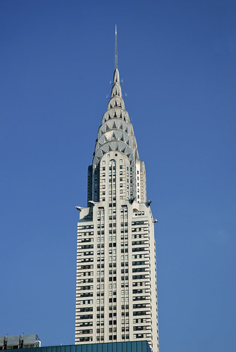
The Chrysler Building is an Art Deco skyscraper in New York City, located on the east side of Manhattan in the Turtle Bay area at the intersection of 42nd Street and Lexington Avenue. Standing at 319 metres (1,047 ft), it was the world's tallest building for 11 months before it was surpassed by the Empire State Building in 1931. After the destruction of the World Trade Center, it was again the second-tallest building in New York City until December 2007, when the spire was raised on the 365.8-metre Bank of America Tower, pushing the Chrysler Building into third position. In addition, The New York Times Building which opened in 2007, is exactly level with the Chrysler Building in height.
The Chrysler Building is a classic example of Art Deco architecture and considered by many contemporary architects to be one of the finest buildings in New York City. In 2007, it was ranked ninth on the List of America's Favorite Architecture by the American Institute of Architects. It was the headquarters of the Chrysler Corporation from 1930 until the mid 1950's, but although the building was built and designed specifically for the car manufacturer, the corporation didn't pay for the construction of it and never owned it, as Walter P. Chrysler decided to pay for it himself, in order for his children to inherit it.
Sunday, March 27, 2011
Monday, March 21, 2011
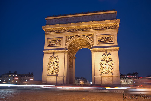
Paris, France - The Arc de Triomphe
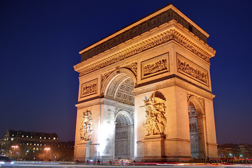
The Arc de Triomphe, is one of the most famous monuments in Paris. It stands in the centre of the Place Charles de Gaulle, at the western end of the Champs-Élysées. There is a smaller arch, the Arc de Triomphe du Carrousel, which stands west of the Louvre. The Arc de Triomphe, honors those who fought and died for France in the French Revolutionary and the Napoleonic Wars, with the names of all French victories and generals inscribed on its inner and outer surfaces. Underneath its vault lies the Tomb of the Unknown Soldier from World War I.
The Arc de Triomphe is the linchpin of the historic axis — a sequence of monuments and grand thoroughfares on a route which goes from the courtyard of the Louvre, to the Grande Arche de la Défense. The monument was designed by Jean Chalgrin in 1806, and its iconographic program pitted heroically nude French youths against bearded Germanic warriors in chain mail. It set the tone for public monuments, with triumphant patriotic messages, until World War I.
Sunday, March 20, 2011
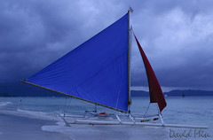
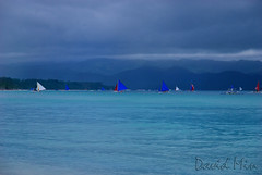
Boracay Island, Philippines - Stormy day @White Beach

Boracay is a tropical island about an hour's flight from Manila in the Philippines. Its long white sand beaches rival the best beaches of more popular destinations such as the Caribbean, the South Pacific as well as neighbouring Thailand, Malaysia and Indonesia.
Facilities are available to suit different levels of activity. For those wanting to just lounge around and take in some rays, beach-front hotels usually have lounge chairs set up just a few steps away from the hotel entrances.
Facilities for the usual water sports activities such as sailing, wind surfing, snorkeling, diving and jet skiing are also widely available for those in search of more active pursuits. The fun in Boracay also doesn't end when the sun sets. Boracay nightlife is pulsating with many bars and restaurants serving food, drink and fun until the very late evening.
Saturday, March 19, 2011
Yokohama, Japan - Minato Mirai 21 harbourside
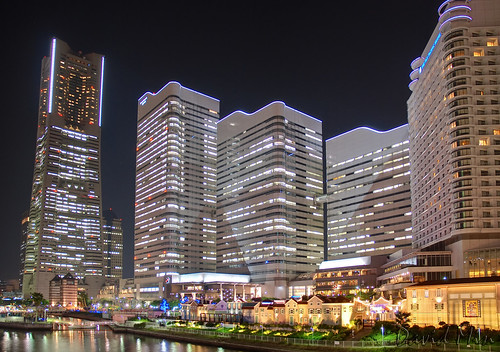
Yokohama is the capital city of Kanagawa Prefecture and the second largest city in Japan by population after Tokyo and most populous municipality of Japan.
It lies on Tokyo Bay, south of Tokyo, in the Kantō region of the main island of Honshū. It is a major commercial hub of the Greater Tokyo Area. Yokohama's population of 3.6 million makes it Japan's largest incorporated city.
Yokohama developed rapidly as Japan's prominent port city following the end of Japan's relative isolation in the mid-19th century, and is today one of its major ports along with Kobe, Osaka, Nagoya, Hakata, Tokyo, and Chiba.
There are various points of interest in the futuristic Minato Mirai 21 harbourside redevelopment. The highlights are the Landmark Tower which is the tallest building in Japan, Queen's Square Yokohama (a shopping mall) and the Cosmo Clock 21, which was the tallest Ferris wheel in the world when it was built in 1989 and which also doubles as "the world's biggest clock".
My heart thoughts and prayers go out to everyone in Japan
Wednesday, March 16, 2011
Paris, France - Fountains on the Place de la Concorde
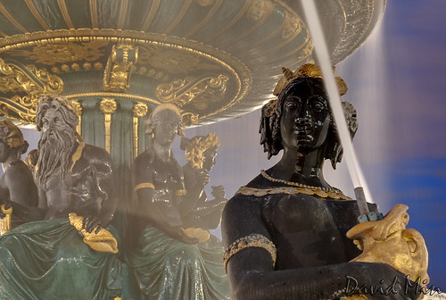
The city of Paris has some of the world's most beautiful fountains. One of the prettiest fountains can be found near the Obelisque at the Place de la Concorde.
The two fountains in the Place de la Concorde have been the most famous of the fountains built during the time of Louis-Philippe, and came to symbolize the fountains in Paris. They were designed by Jacques-Ignace Hittorff, a student of the Neoclassical designer Charles Percier at the Ecole des Beaux-Arts. The German-born Hittorff had served as the official Architect of Festivals and Ceremonies for the deposed King, and had spent two years studying the architecture and fountains of Italy.
Hittorff's two fountains were on the theme of rivers and seas, in part because of their proximity to the Ministry of Navy on the Place de la Concorde, and to the Seine. Their arrangement, on a north-south axis aligned with the obelisk of Luxor, and the Rue Royale, and the form of the fountains themselves, were influenced by the fountains of Rome, particularly Piazza Navona and the Piazza San Pietro, both of which had obelisks aligned with fountains.
Tuesday, March 15, 2011
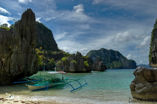
Philippines - Rock formation @Cadlao Lagoon

El Nido is known as the Jewel of Philippine tourism. It is the perfect island destination for naturalists and ecotourists.
It houses one of Palawan's greatest natural treasures: the Bacuit Archipelago.
The Bacuit Archipelago is like Vietnam's Ha Long Bay and the Phi Phi area of southern Thailand, only more beautiful and astonishing. You can explore the bay on a local banca and discover the stunning lagoons and white sand beaches. The place is so romantic that it has inspired a number of impromptu and atypical weddings and the big lagoon has always been the favourite place.
The towering limestone karst cliffs, unique in this town, rank El Nido as anyone's dream. With its limestone cliff scenery, it makes you wonder how such a magical place exists in such a small town. The view from the town's foreshore is simply breathtaking.
Cadlao Island is known locally as “mini Tahiti” and rightfully so. Located at the southwest of the island, about a 25-minute boat ride from the town proper, Cadlao is known for its white-sand beaches, hidden lagoons and lush forest cover. Cadlao beach boasts of fine, creamy white sand, a gradually sloping sea floor, and crystal clear waters. It’s perfect for snorkeling, swimming, and just for wading in. As a bonus, the island is also home to Cadlao Lagoon and its beautiful rock formations. Before entering the lagoon you are greeted by a garden of corals teeming with schools of small colorful fish. The area is good for snorkeling. Of all the islands in El Nido, Cadlao has the highest limestone peak at 609 meters above sea level, with a land area of 1,006 hectares.
Monday, March 14, 2011
Paris, France - Ile de la Cité

The Île de la Cité is one of two natural islands in the Seine within the city of Paris (the other being the Île Saint-Louis). It is the centre of Paris and the location where the medieval city was refounded.
The western end has held a palace since Merovingian times, and its eastern end since the same period has been consecrated to religion, especially after the 10th century construction of a cathedral preceding today's Notre Dame.
The land between the two was, until the 1850s, largely residential and commercial, but since has been filled by the city's Prefecture de Police, Palais de Justice, Hôtel-Dieu hospital and Tribunal de Commerce. Only the westernmost and northeastern extremities of the island remain residential today, and the latter preserves some vestiges of its 16th century canon's houses.
Sunday, March 13, 2011
Philippines - Cadlao Lagoon
El Nido is known as the Jewel of Philippine tourism. It is the perfect island destination for naturalists and ecotourists.
It houses one of Palawan's greatest natural treasures: the Bacuit Archipelago.
The Bacuit Archipelago is like Vietnam's Ha Long Bay and the Phi Phi area of southern Thailand, only more beautiful and astonishing. You can explore the bay on a local banca and discover the stunning lagoons and white sand beaches. The place is so romantic that it has inspired a number of impromptu and atypical weddings and the big lagoon has always been the favourite place.
The towering limestone karst cliffs, unique in this town, rank El Nido as anyone's dream. With its limestone cliff scenery, it makes you wonder how such a magical place exists in such a small town. The view from the town's foreshore is simply breathtaking.
Cadlao Island is known locally as “mini Tahiti” and rightfully so. Located at the southwest of the island, about a 25-minute boat ride from the town proper, Cadlao is known for its white-sand beaches, hidden lagoons and lush forest cover. Cadlao beach boasts of fine, creamy white sand, a gradually sloping sea floor, and crystal clear waters. It’s perfect for snorkeling, swimming, and just for wading in. As a bonus, the island is also home to Cadlao Lagoon and its beautiful rock formations. Before entering the lagoon you are greeted by a garden of corals teeming with schools of small colorful fish. The area is good for snorkeling. Of all the islands in El Nido, Cadlao has the highest limestone peak at 609 meters above sea level, with a land area of 1,006 hectares.
Saturday, March 12, 2011
Paris, France - The Arc de Triomphe
The Arc de Triomphe, is one of the most famous monuments in Paris. It stands in the centre of the Place Charles de Gaulle, at the western end of the Champs-Élysées. There is a smaller arch, the Arc de Triomphe du Carrousel, which stands west of the Louvre. The Arc de Triomphe, honors those who fought and died for France in the French Revolutionary and the Napoleonic Wars, with the names of all French victories and generals inscribed on its inner and outer surfaces. Underneath its vault lies the Tomb of the Unknown Soldier from World War I.
The Arc de Triomphe is the linchpin of the historic axis — a sequence of monuments and grand thoroughfares on a route which goes from the courtyard of the Louvre, to the Grande Arche de la Défense. The monument was designed by Jean Chalgrin in 1806, and its iconographic program pitted heroically nude French youths against bearded Germanic warriors in chain mail. It set the tone for public monuments, with triumphant patriotic messages, until World War I.
Friday, March 11, 2011
Paris, France - A cold night @Pont des Arts
The Pont des Arts or Passerelle des Arts is a pedestrian bridge in Paris which crosses the Seine River. It links the Institut de France and the central square (cour carrée) of the palais du Louvre.
Between 1802 and 1804, a nine-arch metallic bridge for pedestrians was constructed at the location of the present day Pont des Arts: this was the first metal bridge in Paris. This innovation was due to Napoléon I, following a design of English manufacture.
The bridge has sometimes served as a place for art exhibitions, and is today a studio en plein air for painters, artists and photographers who are drawn to its unique point of view. The Pont des Arts is also frequently a spot for picnics during the summer.
Nowadays the bridge has become a hotspot for couples who attach a padlock to the railing and throw the key into the river below.
Wednesday, March 9, 2011
NYC, USA - United Nations Headquarters
The United Nations Organization (UNO) or simply the United Nations (UN) is an international organization whose stated aims are facilitating cooperation in international law, international security, economic development, social progress, human rights, and achievement of world peace. The UN was founded in 1945 after World War II to replace the League of Nations, to stop wars between countries, and to provide a platform for dialogue. It contains multiple subsidiary organizations to carry out its missions.
The headquarters of the United Nations is a distinctive complex in New York City, United States, that has served as the official headquarters of the United Nations since its completion in 1952. It is located in the Turtle Bay neighborhood of Manhattan, on spacious grounds overlooking the East River. Its borders are First Avenue on the west, East 42nd Street to the south, East 48th Street on the north and the East River to the east.Turtle Bay is used as a synonym for the U.N. headquarters or for the U.N. as a whole.
Though it is in New York City, and part of the United States, the land used by the United Nations Headquarters is considered international territory, while also being subject to most local, state, and federal laws. For award purposes Amateur radio operators consider it a separate "entity", and for communications the UN has its own internationally recognized ITU prefix, 4U.
Sunday, March 6, 2011
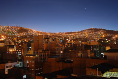
La Paz, Bolivia - Above the roofs
La Paz is the administrative capital of Bolivia. It is located at an elevation of 3,660 meters above sea level, making it the world's highest capital city. The city sits in a "bowl" surrounded by the high mountains of the altiplano. As it grows, La Paz climbs the hills, resulting in varying elevations from 3,000 meters to 4,100 meters. Overlooking the city is towering triple-peaked Illimani, which is always snow-covered and can be seen from several spots of the city, including from the neighbor city, El Alto.
La Paz is an important cultural center of Bolivia. The city hosts several cathedrals belonging to the colonial times, such as the San Francisco Cathedral and the Metropolitan Cathedral, this last one located on Murillo Square, which is also home of the political and administrative power of the country. Hundreds of different museums can be found across the city, the most notable ones on Jaén Street, which street design has been preserved from the Spanish days and is home of 10 different museums.
La Paz is an important cultural center of Bolivia. The city hosts several cathedrals belonging to the colonial times, such as the San Francisco Cathedral and the Metropolitan Cathedral, this last one located on Murillo Square, which is also home of the political and administrative power of the country. Hundreds of different museums can be found across the city, the most notable ones on Jaén Street, which street design has been preserved from the Spanish days and is home of 10 different museums.
Saturday, March 5, 2011
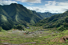
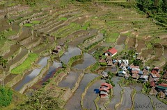
Batad, Philippines - Rice Terraces
In the fastness of the Cordillera mountains, 250-km north of Manila, Ifugao tribespeople have carved a livelihood from bare rock. Over the centuries, generations of Ifugao have laid stone after stone constructing dikes to hold back what little soil washed off the mountainsides creating vertical gardens that rise as "stairways to the heavens."
Rice terraces are common throughout Asia but nowhere are they as spectacular as in the rugged mountains of northern Luzon. The Ifugaos have resisted integration into mainstream society and still practice their traditional farming and religion although headhunting is on the wane.
Batad is a place to reflect, gaze, wonder at the beauty of it all and bask in the pleasure of having such a place on this earth. A tour of the mountainous region of Northern Luzon is not complete without a visit there.
The Batad Rice Terraces are 2000-year old terraces that were carved into the mountains of Ifugao in the Philippines by ancestors of the indigenous people. The Rice Terraces are commonly referred to by Filipinos as the "Eighth Wonder of the World". It is commonly thought that the terraces were built with minimal equipment, largely by hand. The terraces are located approximately 1500 meters above sea level and cover 10,360 square kilometers of mountainside. They are fed by an ancient irrigation system from the rainforests above the terraces. It is said that if the steps are put end to end it would encircle half the globe.
The Batad Rice Terraces are inscribed as a UNESCO World Heritage Site. Locals to this day still plant rice and vegetables on the terraces, although more and more younger Ifugaos do not find farming appealing, often opting for the more lucrative hospitality industry generated by the Rice Terraces. The result is the gradual erosion of the characteristic "steps", which need constant reconstruction and care.
Monday, February 28, 2011
Paris, France - Eiffet Tower
The Eiffel Tower is an 1889 iron lattice tower located on the Champ de Mars in Paris that has become both a global icon of France and one of the most recognizable structures in the world. The Eiffel Tower, which is the tallest building in Paris, is the single most visited paid monument in the world; millions of people ascend it every year. Named after its designer, engineer Gustave Eiffel, the tower was built as the entrance arch for the 1889 World's Fair.
The tower stands 324 m tall, about the same height as an 81-storey building. It was the tallest man-made structure in the world from its completion until the Chrysler Building in New York City was built in 1930.The tower has three levels for visitors. Tickets can be purchased to ascend by stairs or lift to the first and second levels. The walk to the first level is over 300 steps, as is the walk from the first to the second level. The third and highest level is accessible only by lift. Both the first and second levels feature restaurants.

The tower stands 324 m tall, about the same height as an 81-storey building. It was the tallest man-made structure in the world from its completion until the Chrysler Building in New York City was built in 1930.The tower has three levels for visitors. Tickets can be purchased to ascend by stairs or lift to the first and second levels. The walk to the first level is over 300 steps, as is the walk from the first to the second level. The third and highest level is accessible only by lift. Both the first and second levels feature restaurants.
Sunday, February 27, 2011
Boracay Island, Philippines - Sailing Boat @White Beach
Boracay is a tropical island about an hour's flight from Manila in the Philippines. Its long white sand beaches rival the best beaches of more popular destinations such as the Caribbean, the South Pacific as well as neighbouring Thailand, Malaysia and Indonesia.
Facilities are available to suit different levels of activity. For those wanting to just lounge around and take in some rays, beach-front hotels usually have lounge chairs set up just a few steps away from the hotel entrances.
Facilities for the usual water sports activities such as sailing, wind surfing, snorkeling, diving and jet skiing are also widely available for those in search of more active pursuits. The fun in Boracay also doesn't end when the sun sets. Boracay nightlife is pulsating with many bars and restaurants serving food, drink and fun until the very late evening.
Monday, February 21, 2011
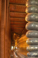
Bangkok, Thailand - Wat Pho, Reclining Buddha
Wat Pho , or Wat Phra Chetuphon as it is generally known to the Thais, is mainly famous for the huge Reclining Buddha statue it houses. At 20 acres large, it is the largest Wat in Bangkok, and is technically the oldest too, as it was built around 200 years before Bangkok became Thailand's capital. However, today the Wat today bears virtually no resemblance to that originally constructed, as it was almost entirely rebuilt by Rama I when the capital was moved to Bangkok. It holds the dual honors of having both Thailand's largest reclining Buddha image and the most number of Buddha images in Thailand.
The highly impressive gold plated reclining Buddha is 46 meters long and 15 meters high, and is designed to illustrate the passing of the Buddha into nirvana. The feet and the eyes are engraved with mother-of-pearl decoration, and the feet also show the 108 auspicious characteristics of the true Buddha.
The highly impressive gold plated reclining Buddha is 46 meters long and 15 meters high, and is designed to illustrate the passing of the Buddha into nirvana. The feet and the eyes are engraved with mother-of-pearl decoration, and the feet also show the 108 auspicious characteristics of the true Buddha.
Sunday, February 13, 2011
Boracay Island, Philippines - Stormy day @White Beach
Boracay is a tropical island about an hour's flight from Manila in the Philippines. Its long white sand beaches rival the best beaches of more popular destinations such as the Caribbean, the South Pacific as well as neighbouring Thailand, Malaysia and Indonesia.
Facilities are available to suit different levels of activity. For those wanting to just lounge around and take in some rays, beach-front hotels usually have lounge chairs set up just a few steps away from the hotel entrances.
Facilities for the usual water sports activities such as sailing, wind surfing, snorkeling, diving and jet skiing are also widely available for those in search of more active pursuits. The fun in Boracay also doesn't end when the sun sets. Boracay nightlife is pulsating with many bars and restaurants serving food, drink and fun until the very late evening.
Facilities are available to suit different levels of activity. For those wanting to just lounge around and take in some rays, beach-front hotels usually have lounge chairs set up just a few steps away from the hotel entrances.
Facilities for the usual water sports activities such as sailing, wind surfing, snorkeling, diving and jet skiing are also widely available for those in search of more active pursuits. The fun in Boracay also doesn't end when the sun sets. Boracay nightlife is pulsating with many bars and restaurants serving food, drink and fun until the very late evening.
Saturday, February 12, 2011
Batad, Philippines - Rice terraces
As part of the Banaue Rice Terraces of the Philippines Cordilleras, the Batad rice terraces are thus also a UNESCO World Heritage Site. Known as the "Eighth Wonder of the World" by the Philippines, they are one of the most well-known attractions of northern Philippines.
Situated in the Ifugao province, the Batad rice terraces rises up to the mountains like an amphitheatre draped in green. It is certainly one of the more spectacular of the rice terraces in the region. These rice terraces are created and passed down almost 2000 years ago by the Ifugao tribemen, who are believed to be descendents of Miao people from southwest China. While most tourists take a day trip from Banaue town to see the terraces, I highly recommend staying a night or two in Batad itself to fully enjoy this wonder.
Besides being able to take walks through the village and the rice terrace at a more leisurely pace, staying in Batad also allows you to see the rice terraces during morning and evening hours. During those times, mists descending into the valley gives the place a otherworldly look, and it is no wonder that the Ifugaos call the rice terraces "Stairway to Heaven".
Getting to Batad does require some logistics though. Typically, you take a public jeepney from Banaue town to Batad Saddle, a mountain ridge, before taking a trek down to Batad village itself. However, these jeepneys operate only in the afternoon and if you take the overnight bus from Manila to Banaue, you find yourself in Banaue early morning. You could wait till afternoon, or you could take the tricycles or motorbikes to the Batad Junction, whereby you would have to trek uphill to the Batad Saddle yourself. The trek takes easily 60-90 minutes and its an uphill climb, so be mentally prepared. The trek from Saddle downhill to Batad is relatively easy.
If you enjoy a quiet sojourn amidst a beautiful setting, go visit Batad and stay overnight !
Thursday, February 10, 2011

Wednesday, February 9, 2011
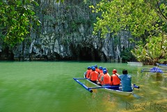
Sabang, Philippines - Underground River
Palawan’s UNESCO World Heritage Site and entrant into the contest for the New 7 Wonders of the Natural World, the underground river near Sabang is officially known as the Puerto Princesa Subterranean River National Park . Located about 50 kilometers north of the city of Puerto Princesa, Palawan, Philippines, the underground river is the second longest in the world since a longer one was recently discovered in Yucatan, Mexico.
Navigable for 8.2 km or over 5 miles, most tourists see the more easily negotiated first 2km. The cave formations are spectacular and include stalactites, stalagmites and columns as well as other formations and of course bats and swallows abound. The entry to the cave in the summer months is a picture postcard azure blue however in the rainy season run off from the land often clouds the water and lessens the crystal clear visibility considerably.
Once something of a torture trek, the trip there from Palawan’s capital city Puerto Princesa is now much faster and far more comfortable after improvements in the road and other infrastructure services were put in place. Gaining World Heritage Listing status in 1999 gave impetus to the local government’s desire to make the river a must-see tourist destination.
Subscribe to:
Posts (Atom)